You are here: Home > Network List > O2 - Oklahoma Consolidated Temporary Seismic Networks Stations List
> Station ARC2 Arcadia, Oklahoma, USA > Earthquake Result Viewer
ARC2 Arcadia, Oklahoma, USA - Earthquake Result Viewer
| Earthquake location: |
Easter Island Region |
| Earthquake latitude/longitude: |
-28.6/-112.3 |
| Earthquake time(UTC): |
2021/12/03 (337) 04:40:04 GMT |
| Earthquake Depth: |
10 km |
| Earthquake Magnitude: |
6.2 mww |
| Earthquake Catalog/Contributor: |
NEIC PDE/us |
|
| Network: |
O2 Oklahoma Consolidated Temporary Seismic Networks |
| Station: |
ARC2 Arcadia, Oklahoma, USA |
| Lat/Lon: |
35.74 N/97.27 W |
| Elevation: |
311 m |
|
| Distance: |
65.6 deg |
| Az: |
13.361 deg |
| Baz: |
194.461 deg |
| Ray Param: |
0.05818213 |
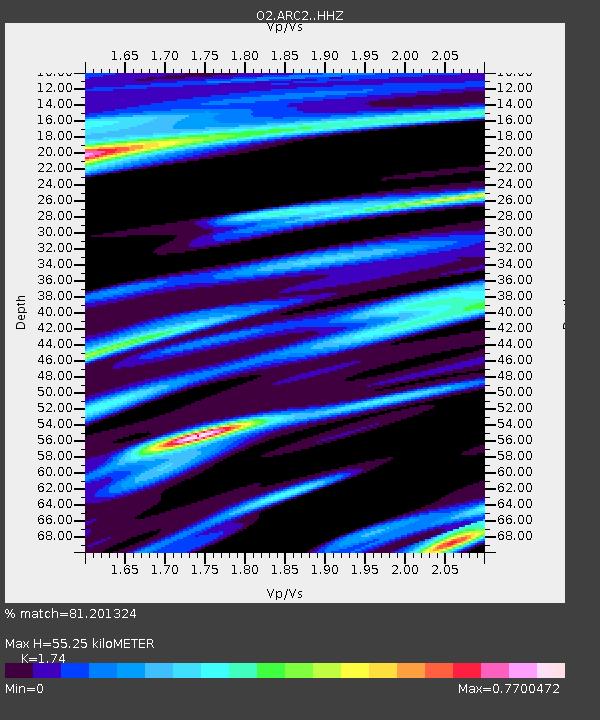
| Estimated Moho Depth: |
55.25 km |
| Estimated Crust Vp/Vs: |
1.74 |
| Assumed Crust Vp: |
6.426 km/s |
| Estimated Crust Vs: |
3.693 km/s |
| Estimated Crust Poisson's Ratio: |
0.25 |
|
| Radial Match: |
81.201324 % |
| Radial Bump: |
337 |
| Transverse Match: |
56.13234 % |
| Transverse Bump: |
400 |
| SOD ConfigId: |
26694651 |
| Insert Time: |
2021-12-17 04:57:31.852 +0000 |
| GWidth: |
2.5 |
| Max Bumps: |
400 |
| Tol: |
0.001 |
|

Signal To Noise
| Channel | StoN | STA | LTA |
| O2:ARC2: :HHZ:20211203T04:50:16.610017Z | 4.5673 | 1.0393212E-6 | 2.2755704E-7 |
| O2:ARC2: :HHN:20211203T04:50:16.610017Z | 1.9545429 | 4.4824088E-7 | 2.2933284E-7 |
| O2:ARC2: :HHE:20211203T04:50:16.610017Z | 1.0171368 | 2.6855497E-7 | 2.6403032E-7 |
| Arrivals |
| Ps | 6.6 SECOND |
| PpPs | 23 SECOND |
| PsPs/PpSs | 29 SECOND |


