You are here: Home > Network List > TX - Texas Seismological Network Stations List
> Station PLPT Palo Pinto > Earthquake Result Viewer
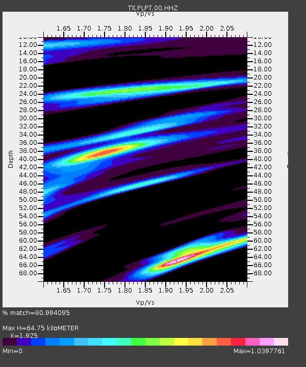
PLPT Palo Pinto - Earthquake Result Viewer
| Earthquake location: |
Easter Island Region |
| Earthquake latitude/longitude: |
-28.6/-112.3 |
| Earthquake time(UTC): |
2021/12/03 (337) 04:40:04 GMT |
| Earthquake Depth: |
10 km |
| Earthquake Magnitude: |
6.2 mww |
| Earthquake Catalog/Contributor: |
NEIC PDE/us |
|
| Network: |
TX Texas Seismological Network |
| Station: |
PLPT Palo Pinto |
| Lat/Lon: |
32.81 N/98.32 W |
| Elevation: |
336 m |
|
| Distance: |
62.5 deg |
| Az: |
13.223 deg |
| Baz: |
193.815 deg |
| Ray Param: |
0.060169928 |
| Estimated Moho Depth: |
64.75 km |
| Estimated Crust Vp/Vs: |
1.92 |
| Assumed Crust Vp: |
6.426 km/s |
| Estimated Crust Vs: |
3.338 km/s |
| Estimated Crust Poisson's Ratio: |
0.32 |
|
| Radial Match: |
80.994095 % |
| Radial Bump: |
321 |
| Transverse Match: |
51.100986 % |
| Transverse Bump: |
400 |
| SOD ConfigId: |
26694651 |
| Insert Time: |
2021-12-17 05:03:31.827 +0000 |
| GWidth: |
2.5 |
| Max Bumps: |
400 |
| Tol: |
0.001 |
|

Signal To Noise
| Channel | StoN | STA | LTA |
| TX:PLPT:00:HHZ:20211203T04:49:56.63498Z | 3.772074 | 6.514794E-7 | 1.7271118E-7 |
| TX:PLPT:00:HH1:20211203T04:49:56.63498Z | 1.178844 | 2.0283957E-7 | 1.720665E-7 |
| TX:PLPT:00:HH2:20211203T04:49:56.63498Z | 1.5304492 | 3.598564E-7 | 2.3513122E-7 |
| Arrivals |
| Ps | 9.7 SECOND |
| PpPs | 28 SECOND |
| PsPs/PpSs | 38 SECOND |


