You are here: Home > Network List > US - United States National Seismic Network Stations List
> Station MNTX Cornudas Mountains, Texas, USA > Earthquake Result Viewer
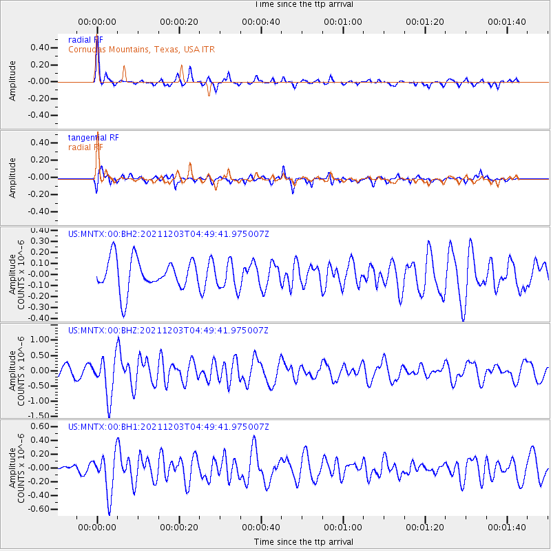
MNTX Cornudas Mountains, Texas, USA - Earthquake Result Viewer
*The percent match for this event was below the threshold and hence no stack was calculated.
| Earthquake location: |
Easter Island Region |
| Earthquake latitude/longitude: |
-28.6/-112.3 |
| Earthquake time(UTC): |
2021/12/03 (337) 04:40:04 GMT |
| Earthquake Depth: |
10 km |
| Earthquake Magnitude: |
6.2 mww |
| Earthquake Catalog/Contributor: |
NEIC PDE/us |
|
| Network: |
US United States National Seismic Network |
| Station: |
MNTX Cornudas Mountains, Texas, USA |
| Lat/Lon: |
31.70 N/105.38 W |
| Elevation: |
405 m |
|
| Distance: |
60.4 deg |
| Az: |
6.747 deg |
| Baz: |
186.959 deg |
| Ray Param: |
$rayparam |
*The percent match for this event was below the threshold and hence was not used in the summary stack. |
|
| Radial Match: |
79.30469 % |
| Radial Bump: |
315 |
| Transverse Match: |
69.52749 % |
| Transverse Bump: |
400 |
| SOD ConfigId: |
26694651 |
| Insert Time: |
2021-12-17 05:05:24.344 +0000 |
| GWidth: |
2.5 |
| Max Bumps: |
400 |
| Tol: |
0.001 |
|
Signal To Noise
| Channel | StoN | STA | LTA |
| US:MNTX:00:BHZ:20211203T04:49:41.975007Z | 3.7586343 | 6.6479146E-7 | 1.7687047E-7 |
| US:MNTX:00:BH1:20211203T04:49:41.975007Z | 4.2105246 | 2.980993E-7 | 7.079861E-8 |
| US:MNTX:00:BH2:20211203T04:49:41.975007Z | 0.8866097 | 1.2520866E-7 | 1.4122185E-7 |
| Arrivals |
| Ps | |
| PpPs | |
| PsPs/PpSs | |


