You are here: Home > Network List > UW - Pacific Northwest Regional Seismic Network Stations List
> Station UMAT Pilot Rock, OR, USA > Earthquake Result Viewer
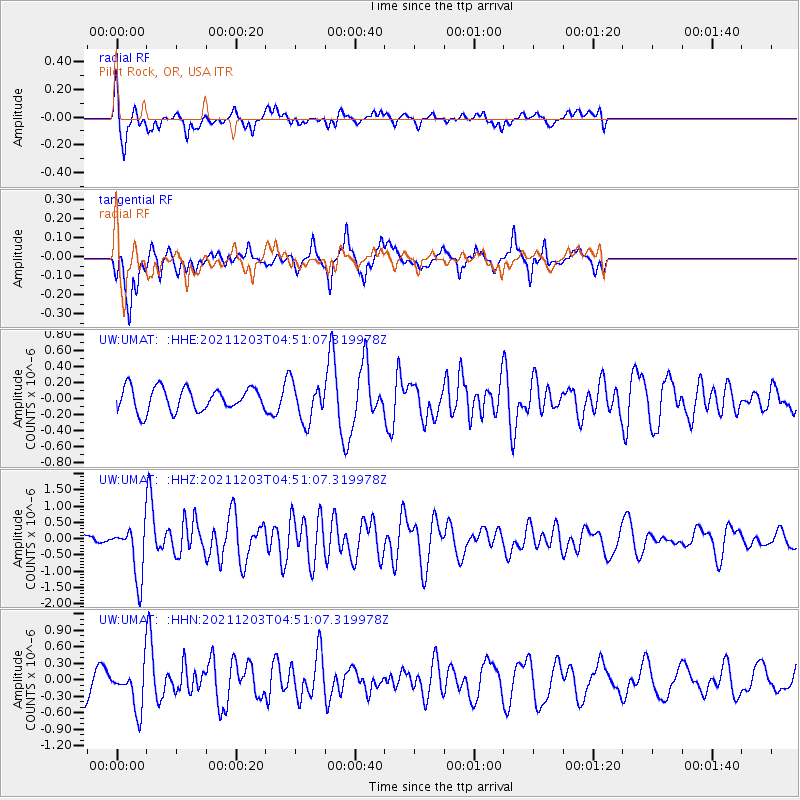
UMAT Pilot Rock, OR, USA - Earthquake Result Viewer
*The percent match for this event was below the threshold and hence no stack was calculated.
| Earthquake location: |
Easter Island Region |
| Earthquake latitude/longitude: |
-28.6/-112.3 |
| Earthquake time(UTC): |
2021/12/03 (337) 04:40:04 GMT |
| Earthquake Depth: |
10 km |
| Earthquake Magnitude: |
6.2 mww |
| Earthquake Catalog/Contributor: |
NEIC PDE/us |
|
| Network: |
UW Pacific Northwest Regional Seismic Network |
| Station: |
UMAT Pilot Rock, OR, USA |
| Lat/Lon: |
45.29 N/118.96 W |
| Elevation: |
1318 m |
|
| Distance: |
73.8 deg |
| Az: |
355.082 deg |
| Baz: |
173.871 deg |
| Ray Param: |
$rayparam |
*The percent match for this event was below the threshold and hence was not used in the summary stack. |
|
| Radial Match: |
46.11412 % |
| Radial Bump: |
386 |
| Transverse Match: |
66.66284 % |
| Transverse Bump: |
394 |
| SOD ConfigId: |
26694651 |
| Insert Time: |
2021-12-17 05:07:05.218 +0000 |
| GWidth: |
2.5 |
| Max Bumps: |
400 |
| Tol: |
0.001 |
|
Signal To Noise
| Channel | StoN | STA | LTA |
| UW:UMAT: :HHZ:20211203T04:51:07.319978Z | 6.5183916 | 8.1713694E-7 | 1.2535867E-7 |
| UW:UMAT: :HHN:20211203T04:51:07.319978Z | 1.1271511 | 3.895744E-7 | 3.4562748E-7 |
| UW:UMAT: :HHE:20211203T04:51:07.319978Z | 1.6666782 | 2.4129054E-7 | 1.4477332E-7 |
| Arrivals |
| Ps | |
| PpPs | |
| PsPs/PpSs | |


