You are here: Home > Network List > YL01 - Himalayan Nepal Tibet Experiment Stations List
> Station SSAN YL.SSAN > Earthquake Result Viewer
SSAN YL.SSAN - Earthquake Result Viewer
| Earthquake location: |
Minahassa Peninsula, Sulawesi |
| Earthquake latitude/longitude: |
-0.0/122.9 |
| Earthquake time(UTC): |
2001/12/09 (343) 18:15:02 GMT |
| Earthquake Depth: |
156 km |
| Earthquake Magnitude: |
5.7 MB, 6.2 MW, 6.0 MW |
| Earthquake Catalog/Contributor: |
WHDF/NEIC |
|
| Network: |
YL Himalayan Nepal Tibet Experiment |
| Station: |
SSAN YL.SSAN |
| Lat/Lon: |
29.42 N/86.73 E |
| Elevation: |
4585 m |
|
| Distance: |
45.2 deg |
| Az: |
313.53 deg |
| Baz: |
123.795 deg |
| Ray Param: |
0.07084796 |
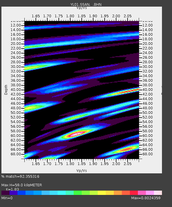
| Estimated Moho Depth: |
59.0 km |
| Estimated Crust Vp/Vs: |
1.83 |
| Assumed Crust Vp: |
6.514 km/s |
| Estimated Crust Vs: |
3.56 km/s |
| Estimated Crust Poisson's Ratio: |
0.29 |
|
| Radial Match: |
92.355316 % |
| Radial Bump: |
398 |
| Transverse Match: |
86.372696 % |
| Transverse Bump: |
400 |
| SOD ConfigId: |
16820 |
| Insert Time: |
2010-02-26 16:13:04.683 +0000 |
| GWidth: |
2.5 |
| Max Bumps: |
400 |
| Tol: |
0.001 |
|
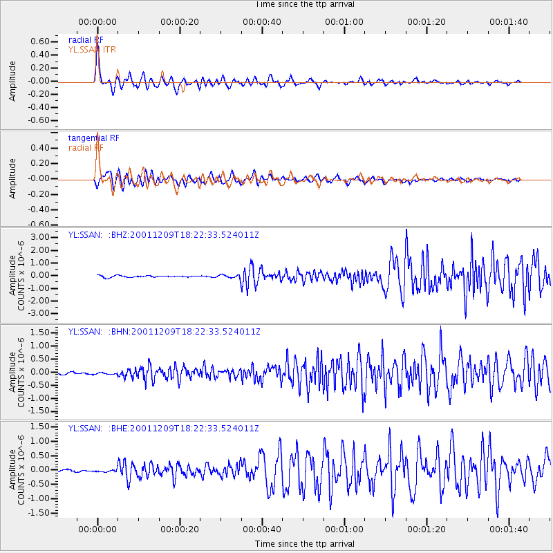
Signal To Noise
| Channel | StoN | STA | LTA |
| YL:SSAN: :BHN:20011209T18:22:33.524011Z | 0.8170092 | 3.86808E-8 | 4.7344386E-8 |
| YL:SSAN: :BHE:20011209T18:22:33.524011Z | 1.0117333 | 4.38422E-8 | 4.333375E-8 |
| YL:SSAN: :BHZ:20011209T18:22:33.524011Z | 2.1054177 | 1.3417852E-7 | 6.373012E-8 |
| Arrivals |
| Ps | 8.0 SECOND |
| PpPs | 24 SECOND |
| PsPs/PpSs | 32 SECOND |


