You are here: Home > Network List > AK - Alaska Regional Network Stations List
> Station H24K Noodor Dome, AK, USA > Earthquake Result Viewer
H24K Noodor Dome, AK, USA - Earthquake Result Viewer
| Earthquake location: |
North Of Halmahera, Indonesia |
| Earthquake latitude/longitude: |
4.1/128.1 |
| Earthquake time(UTC): |
2021/12/04 (338) 23:47:57 GMT |
| Earthquake Depth: |
174 km |
| Earthquake Magnitude: |
6.0 mww |
| Earthquake Catalog/Contributor: |
NEIC PDE/us |
|
| Network: |
AK Alaska Regional Network |
| Station: |
H24K Noodor Dome, AK, USA |
| Lat/Lon: |
65.84 N/147.88 W |
| Elevation: |
814 m |
|
| Distance: |
83.8 deg |
| Az: |
24.314 deg |
| Baz: |
266.18 deg |
| Ray Param: |
0.045496706 |
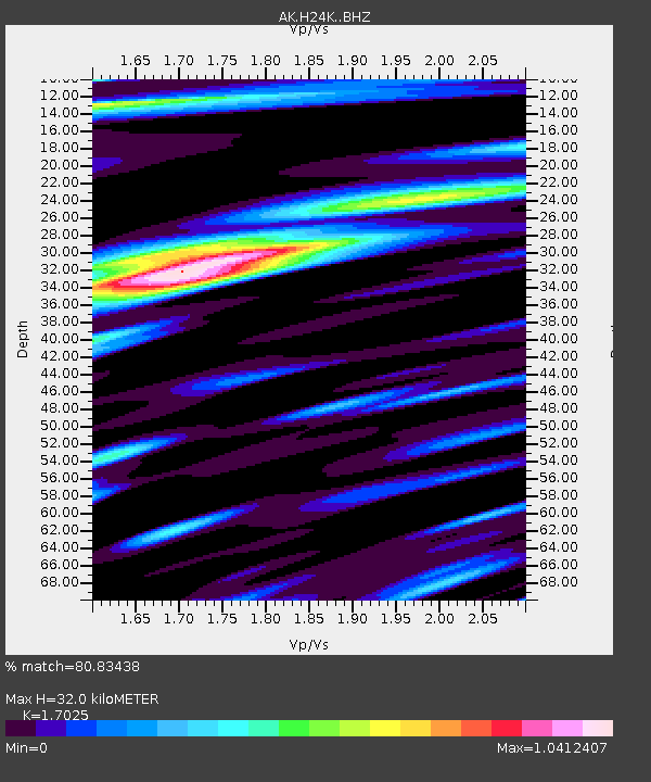
| Estimated Moho Depth: |
32.0 km |
| Estimated Crust Vp/Vs: |
1.70 |
| Assumed Crust Vp: |
6.566 km/s |
| Estimated Crust Vs: |
3.857 km/s |
| Estimated Crust Poisson's Ratio: |
0.24 |
|
| Radial Match: |
80.83438 % |
| Radial Bump: |
400 |
| Transverse Match: |
74.94184 % |
| Transverse Bump: |
400 |
| SOD ConfigId: |
26694651 |
| Insert Time: |
2021-12-18 23:50:26.128 +0000 |
| GWidth: |
2.5 |
| Max Bumps: |
400 |
| Tol: |
0.001 |
|

Signal To Noise
| Channel | StoN | STA | LTA |
| AK:H24K: :BHZ:20211204T23:59:36.479973Z | 29.698444 | 4.587849E-6 | 1.5448113E-7 |
| AK:H24K: :BHN:20211204T23:59:36.479973Z | 3.6345792 | 1.033715E-6 | 2.844112E-7 |
| AK:H24K: :BHE:20211204T23:59:36.479973Z | 5.1076508 | 1.2499612E-6 | 2.4472328E-7 |
| Arrivals |
| Ps | 3.5 SECOND |
| PpPs | 13 SECOND |
| PsPs/PpSs | 16 SECOND |


