You are here: Home > Network List > AU - Australian Seismological Centre Stations List
> Station ARMA Armidale, New South Wales > Earthquake Result Viewer
ARMA Armidale, New South Wales - Earthquake Result Viewer
| Earthquake location: |
North Of Halmahera, Indonesia |
| Earthquake latitude/longitude: |
4.1/128.1 |
| Earthquake time(UTC): |
2021/12/04 (338) 23:47:57 GMT |
| Earthquake Depth: |
174 km |
| Earthquake Magnitude: |
6.0 mww |
| Earthquake Catalog/Contributor: |
NEIC PDE/us |
|
| Network: |
AU Australian Seismological Centre |
| Station: |
ARMA Armidale, New South Wales |
| Lat/Lon: |
30.42 S/151.63 E |
| Elevation: |
1112 m |
|
| Distance: |
41.0 deg |
| Az: |
148.336 deg |
| Baz: |
322.687 deg |
| Ray Param: |
0.07338727 |
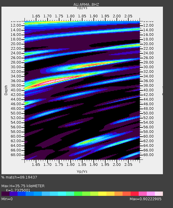
| Estimated Moho Depth: |
35.75 km |
| Estimated Crust Vp/Vs: |
1.73 |
| Assumed Crust Vp: |
6.577 km/s |
| Estimated Crust Vs: |
3.796 km/s |
| Estimated Crust Poisson's Ratio: |
0.25 |
|
| Radial Match: |
89.19437 % |
| Radial Bump: |
400 |
| Transverse Match: |
79.64199 % |
| Transverse Bump: |
400 |
| SOD ConfigId: |
26694651 |
| Insert Time: |
2021-12-18 23:53:31.557 +0000 |
| GWidth: |
2.5 |
| Max Bumps: |
400 |
| Tol: |
0.001 |
|

Signal To Noise
| Channel | StoN | STA | LTA |
| AU:ARMA: :BHZ:20211204T23:54:53.119011Z | 33.06536 | 1.1011446E-5 | 3.3302058E-7 |
| AU:ARMA: :BHN:20211204T23:54:53.119011Z | 21.895258 | 6.350647E-6 | 2.9004667E-7 |
| AU:ARMA: :BHE:20211204T23:54:53.119011Z | 19.360493 | 5.332848E-6 | 2.7545005E-7 |
| Arrivals |
| Ps | 4.3 SECOND |
| PpPs | 14 SECOND |
| PsPs/PpSs | 18 SECOND |


