You are here: Home > Network List > AV - Alaska Volcano Observatory Stations List
> Station ACH Angle Creek Headwaters, Katmai, Alaska > Earthquake Result Viewer
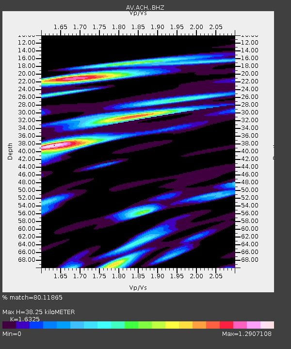
ACH Angle Creek Headwaters, Katmai, Alaska - Earthquake Result Viewer
| Earthquake location: |
North Of Halmahera, Indonesia |
| Earthquake latitude/longitude: |
4.1/128.1 |
| Earthquake time(UTC): |
2021/12/04 (338) 23:47:57 GMT |
| Earthquake Depth: |
174 km |
| Earthquake Magnitude: |
6.0 mww |
| Earthquake Catalog/Contributor: |
NEIC PDE/us |
|
| Network: |
AV Alaska Volcano Observatory |
| Station: |
ACH Angle Creek Headwaters, Katmai, Alaska |
| Lat/Lon: |
58.21 N/155.33 W |
| Elevation: |
960 m |
|
| Distance: |
79.5 deg |
| Az: |
31.576 deg |
| Baz: |
260.649 deg |
| Ray Param: |
0.0485174 |
| Estimated Moho Depth: |
38.25 km |
| Estimated Crust Vp/Vs: |
1.63 |
| Assumed Crust Vp: |
6.438 km/s |
| Estimated Crust Vs: |
3.944 km/s |
| Estimated Crust Poisson's Ratio: |
0.20 |
|
| Radial Match: |
80.11865 % |
| Radial Bump: |
400 |
| Transverse Match: |
76.54821 % |
| Transverse Bump: |
400 |
| SOD ConfigId: |
26694651 |
| Insert Time: |
2021-12-18 23:54:08.830 +0000 |
| GWidth: |
2.5 |
| Max Bumps: |
400 |
| Tol: |
0.001 |
|

Signal To Noise
| Channel | StoN | STA | LTA |
| AV:ACH: :BHZ:20211204T23:59:13.68798Z | 9.954005 | 2.2238603E-6 | 2.2341362E-7 |
| AV:ACH: :BHN:20211204T23:59:13.68798Z | 5.1062393 | 1.2442937E-6 | 2.4368103E-7 |
| AV:ACH: :BHE:20211204T23:59:13.68798Z | 8.779198 | 2.0519342E-6 | 2.3372684E-7 |
| Arrivals |
| Ps | 3.9 SECOND |
| PpPs | 15 SECOND |
| PsPs/PpSs | 19 SECOND |


