You are here: Home > Network List > AV - Alaska Volcano Observatory Stations List
> Station AMKA Regional Station, Amchitka Island, Alaska > Earthquake Result Viewer
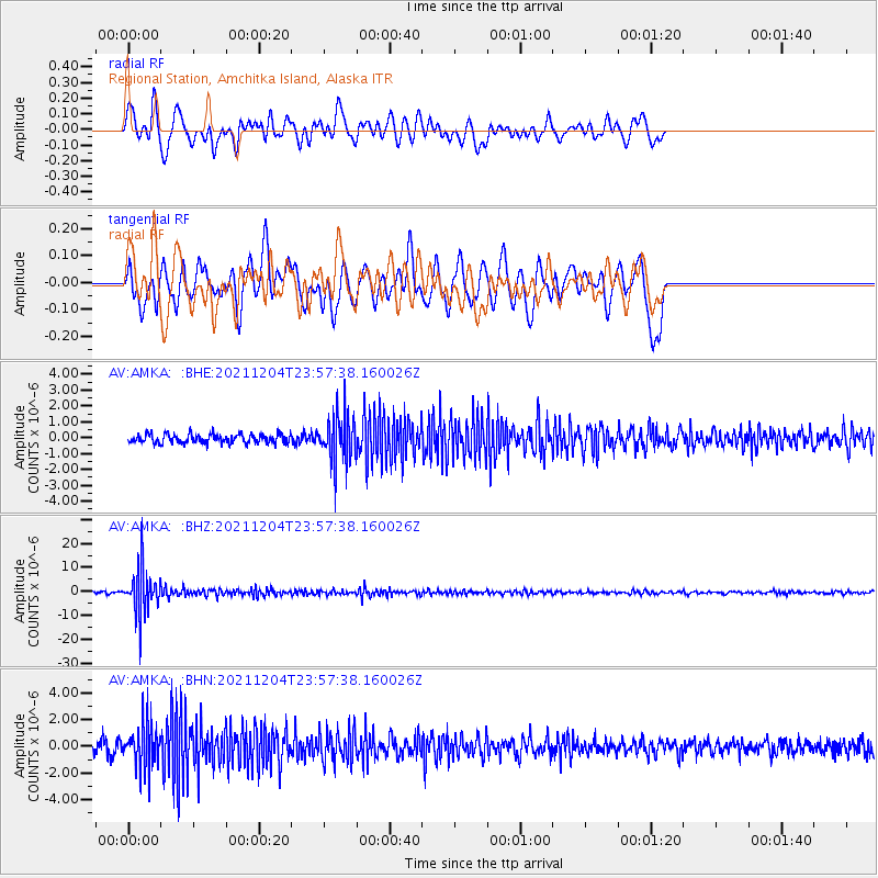
AMKA Regional Station, Amchitka Island, Alaska - Earthquake Result Viewer
*The percent match for this event was below the threshold and hence no stack was calculated.
| Earthquake location: |
North Of Halmahera, Indonesia |
| Earthquake latitude/longitude: |
4.1/128.1 |
| Earthquake time(UTC): |
2021/12/04 (338) 23:47:57 GMT |
| Earthquake Depth: |
174 km |
| Earthquake Magnitude: |
6.0 mww |
| Earthquake Catalog/Contributor: |
NEIC PDE/us |
|
| Network: |
AV Alaska Volcano Observatory |
| Station: |
AMKA Regional Station, Amchitka Island, Alaska |
| Lat/Lon: |
51.38 N/179.30 E |
| Elevation: |
116 m |
|
| Distance: |
63.5 deg |
| Az: |
33.076 deg |
| Baz: |
240.298 deg |
| Ray Param: |
$rayparam |
*The percent match for this event was below the threshold and hence was not used in the summary stack. |
|
| Radial Match: |
68.069244 % |
| Radial Bump: |
400 |
| Transverse Match: |
57.600914 % |
| Transverse Bump: |
400 |
| SOD ConfigId: |
26694651 |
| Insert Time: |
2021-12-18 23:54:26.374 +0000 |
| GWidth: |
2.5 |
| Max Bumps: |
400 |
| Tol: |
0.001 |
|
Signal To Noise
| Channel | StoN | STA | LTA |
| AV:AMKA: :BHZ:20211204T23:57:38.160026Z | 25.61732 | 9.184275E-6 | 3.5851818E-7 |
| AV:AMKA: :BHN:20211204T23:57:38.160026Z | 5.440119 | 1.6276744E-6 | 2.9919832E-7 |
| AV:AMKA: :BHE:20211204T23:57:38.160026Z | 5.341737 | 1.4798275E-6 | 2.7703115E-7 |
| Arrivals |
| Ps | |
| PpPs | |
| PsPs/PpSs | |


