You are here: Home > Network List > AV - Alaska Volcano Observatory Stations List
> Station PLBL Mt. Peulik Volcano, Alaska > Earthquake Result Viewer
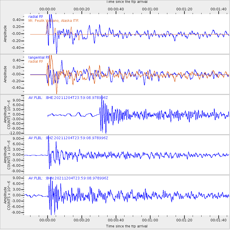
PLBL Mt. Peulik Volcano, Alaska - Earthquake Result Viewer
*The percent match for this event was below the threshold and hence no stack was calculated.
| Earthquake location: |
North Of Halmahera, Indonesia |
| Earthquake latitude/longitude: |
4.1/128.1 |
| Earthquake time(UTC): |
2021/12/04 (338) 23:47:57 GMT |
| Earthquake Depth: |
174 km |
| Earthquake Magnitude: |
6.0 mww |
| Earthquake Catalog/Contributor: |
NEIC PDE/us |
|
| Network: |
AV Alaska Volcano Observatory |
| Station: |
PLBL Mt. Peulik Volcano, Alaska |
| Lat/Lon: |
57.70 N/156.82 W |
| Elevation: |
461 m |
|
| Distance: |
78.6 deg |
| Az: |
31.95 deg |
| Baz: |
259.457 deg |
| Ray Param: |
$rayparam |
*The percent match for this event was below the threshold and hence was not used in the summary stack. |
|
| Radial Match: |
64.96145 % |
| Radial Bump: |
400 |
| Transverse Match: |
60.00528 % |
| Transverse Bump: |
400 |
| SOD ConfigId: |
26694651 |
| Insert Time: |
2021-12-18 23:56:15.435 +0000 |
| GWidth: |
2.5 |
| Max Bumps: |
400 |
| Tol: |
0.001 |
|
Signal To Noise
| Channel | StoN | STA | LTA |
| AV:PLBL: :BHZ:20211204T23:59:08.978996Z | 12.515829 | 3.7863226E-6 | 3.0252272E-7 |
| AV:PLBL: :BHN:20211204T23:59:08.978996Z | 13.296987 | 4.348809E-6 | 3.2705222E-7 |
| AV:PLBL: :BHE:20211204T23:59:08.978996Z | 9.274947 | 5.6390945E-6 | 6.079921E-7 |
| Arrivals |
| Ps | |
| PpPs | |
| PsPs/PpSs | |


