You are here: Home > Network List > AV - Alaska Volcano Observatory Stations List
> Station SPWE Spurr West, Mount Spurr, Alaska > Earthquake Result Viewer
SPWE Spurr West, Mount Spurr, Alaska - Earthquake Result Viewer
| Earthquake location: |
North Of Halmahera, Indonesia |
| Earthquake latitude/longitude: |
4.1/128.1 |
| Earthquake time(UTC): |
2021/12/04 (338) 23:47:57 GMT |
| Earthquake Depth: |
174 km |
| Earthquake Magnitude: |
6.0 mww |
| Earthquake Catalog/Contributor: |
NEIC PDE/us |
|
| Network: |
AV Alaska Volcano Observatory |
| Station: |
SPWE Spurr West, Mount Spurr, Alaska |
| Lat/Lon: |
61.27 N/152.56 W |
| Elevation: |
1317 m |
|
| Distance: |
81.3 deg |
| Az: |
28.701 deg |
| Baz: |
262.558 deg |
| Ray Param: |
0.04725548 |
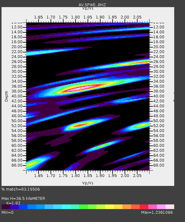
| Estimated Moho Depth: |
36.5 km |
| Estimated Crust Vp/Vs: |
1.82 |
| Assumed Crust Vp: |
6.566 km/s |
| Estimated Crust Vs: |
3.608 km/s |
| Estimated Crust Poisson's Ratio: |
0.28 |
|
| Radial Match: |
83.15506 % |
| Radial Bump: |
400 |
| Transverse Match: |
83.455284 % |
| Transverse Bump: |
400 |
| SOD ConfigId: |
26694651 |
| Insert Time: |
2021-12-18 23:57:14.022 +0000 |
| GWidth: |
2.5 |
| Max Bumps: |
400 |
| Tol: |
0.001 |
|

Signal To Noise
| Channel | StoN | STA | LTA |
| AV:SPWE: :BHZ:20211204T23:59:23.439018Z | 10.8468485 | 1.9587803E-6 | 1.805852E-7 |
| AV:SPWE: :BHN:20211204T23:59:23.439018Z | 3.2583067 | 5.4434196E-7 | 1.6706282E-7 |
| AV:SPWE: :BHE:20211204T23:59:23.439018Z | 4.8397145 | 7.2368465E-7 | 1.4953045E-7 |
| Arrivals |
| Ps | 4.7 SECOND |
| PpPs | 15 SECOND |
| PsPs/PpSs | 20 SECOND |


