You are here: Home > Network List > C8 - Canadian Seismic Research Network () Stations List
> Station GRIB Gribbell Island, BC, CA > Earthquake Result Viewer
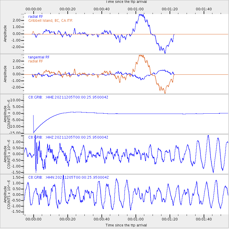
GRIB Gribbell Island, BC, CA - Earthquake Result Viewer
*The percent match for this event was below the threshold and hence no stack was calculated.
| Earthquake location: |
North Of Halmahera, Indonesia |
| Earthquake latitude/longitude: |
4.1/128.1 |
| Earthquake time(UTC): |
2021/12/04 (338) 23:47:57 GMT |
| Earthquake Depth: |
174 km |
| Earthquake Magnitude: |
6.0 mww |
| Earthquake Catalog/Contributor: |
NEIC PDE/us |
|
| Network: |
C8 Canadian Seismic Research Network () |
| Station: |
GRIB Gribbell Island, BC, CA |
| Lat/Lon: |
53.34 N/129.14 W |
| Elevation: |
418 m |
|
| Distance: |
94.3 deg |
| Az: |
35.916 deg |
| Baz: |
282.634 deg |
| Ray Param: |
$rayparam |
*The percent match for this event was below the threshold and hence was not used in the summary stack. |
|
| Radial Match: |
28.516514 % |
| Radial Bump: |
400 |
| Transverse Match: |
35.24411 % |
| Transverse Bump: |
400 |
| SOD ConfigId: |
26694651 |
| Insert Time: |
2021-12-18 23:58:39.359 +0000 |
| GWidth: |
2.5 |
| Max Bumps: |
400 |
| Tol: |
0.001 |
|
Signal To Noise
| Channel | StoN | STA | LTA |
| C8:GRIB: :HHZ:20211205T00:00:25.950004Z | 0.8964634 | 6.256942E-7 | 6.9795846E-7 |
| C8:GRIB: :HHN:20211205T00:00:25.950004Z | 0.83893293 | 4.243753E-7 | 5.058513E-7 |
| C8:GRIB: :HHE:20211205T00:00:25.950004Z | 0.91304344 | 4.2069187E-6 | 4.6075775E-6 |
| Arrivals |
| Ps | |
| PpPs | |
| PsPs/PpSs | |


