You are here: Home > Network List > G - GEOSCOPE Stations List
> Station FOMA Nahampoana reservation, Fort Dauphin, Madagascar > Earthquake Result Viewer
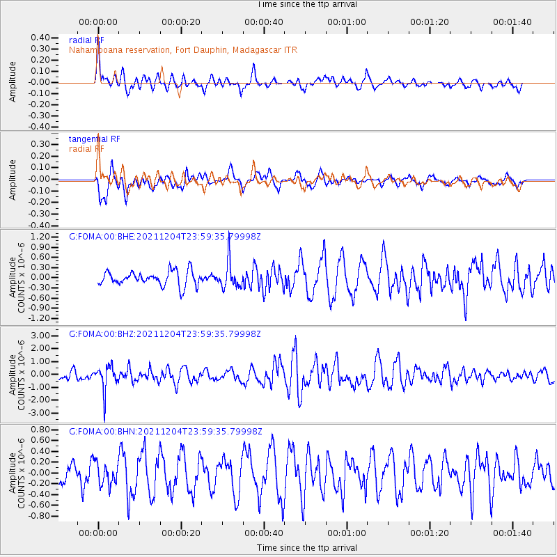
FOMA Nahampoana reservation, Fort Dauphin, Madagascar - Earthquake Result Viewer
*The percent match for this event was below the threshold and hence no stack was calculated.
| Earthquake location: |
North Of Halmahera, Indonesia |
| Earthquake latitude/longitude: |
4.1/128.1 |
| Earthquake time(UTC): |
2021/12/04 (338) 23:47:57 GMT |
| Earthquake Depth: |
174 km |
| Earthquake Magnitude: |
6.0 mww |
| Earthquake Catalog/Contributor: |
NEIC PDE/us |
|
| Network: |
G GEOSCOPE |
| Station: |
FOMA Nahampoana reservation, Fort Dauphin, Madagascar |
| Lat/Lon: |
24.98 S/46.98 E |
| Elevation: |
26 m |
|
| Distance: |
83.7 deg |
| Az: |
244.451 deg |
| Baz: |
82.581 deg |
| Ray Param: |
$rayparam |
*The percent match for this event was below the threshold and hence was not used in the summary stack. |
|
| Radial Match: |
56.97027 % |
| Radial Bump: |
400 |
| Transverse Match: |
51.736797 % |
| Transverse Bump: |
400 |
| SOD ConfigId: |
26694651 |
| Insert Time: |
2021-12-19 00:01:01.111 +0000 |
| GWidth: |
2.5 |
| Max Bumps: |
400 |
| Tol: |
0.001 |
|
Signal To Noise
| Channel | StoN | STA | LTA |
| G:FOMA:00:BHZ:20211204T23:59:35.79998Z | 3.7176456 | 9.94482E-7 | 2.6750317E-7 |
| G:FOMA:00:BHN:20211204T23:59:35.79998Z | 0.8136981 | 1.9408665E-7 | 2.3852417E-7 |
| G:FOMA:00:BHE:20211204T23:59:35.79998Z | 1.9237822 | 4.07131E-7 | 2.116305E-7 |
| Arrivals |
| Ps | |
| PpPs | |
| PsPs/PpSs | |


