You are here: Home > Network List > MM - Myanmar National Seismic Network Stations List
> Station NGU Ngaung U, Myanmar > Earthquake Result Viewer
NGU Ngaung U, Myanmar - Earthquake Result Viewer
| Earthquake location: |
North Of Halmahera, Indonesia |
| Earthquake latitude/longitude: |
4.1/128.1 |
| Earthquake time(UTC): |
2021/12/04 (338) 23:47:57 GMT |
| Earthquake Depth: |
174 km |
| Earthquake Magnitude: |
6.0 mww |
| Earthquake Catalog/Contributor: |
NEIC PDE/us |
|
| Network: |
MM Myanmar National Seismic Network |
| Station: |
NGU Ngaung U, Myanmar |
| Lat/Lon: |
21.21 N/94.92 E |
| Elevation: |
70 m |
|
| Distance: |
36.5 deg |
| Az: |
300.715 deg |
| Baz: |
113.21 deg |
| Ray Param: |
0.076035164 |
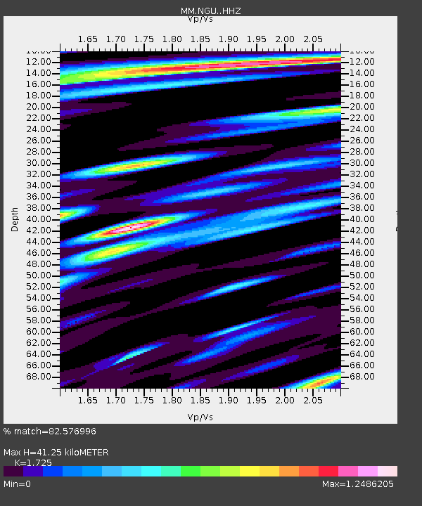
| Estimated Moho Depth: |
41.25 km |
| Estimated Crust Vp/Vs: |
1.73 |
| Assumed Crust Vp: |
6.036 km/s |
| Estimated Crust Vs: |
3.499 km/s |
| Estimated Crust Poisson's Ratio: |
0.25 |
|
| Radial Match: |
82.576996 % |
| Radial Bump: |
400 |
| Transverse Match: |
70.11147 % |
| Transverse Bump: |
395 |
| SOD ConfigId: |
26694651 |
| Insert Time: |
2021-12-19 00:06:19.555 +0000 |
| GWidth: |
2.5 |
| Max Bumps: |
400 |
| Tol: |
0.001 |
|

Signal To Noise
| Channel | StoN | STA | LTA |
| MM:NGU: :HHZ:20211204T23:54:15.649986Z | 27.970413 | 8.441424E-6 | 3.017983E-7 |
| MM:NGU: :HHN:20211204T23:54:15.649986Z | 6.5719347 | 1.4807794E-6 | 2.2531863E-7 |
| MM:NGU: :HHE:20211204T23:54:15.649986Z | 6.004874 | 1.9043641E-6 | 3.171364E-7 |
| Arrivals |
| Ps | 5.3 SECOND |
| PpPs | 17 SECOND |
| PsPs/PpSs | 23 SECOND |


