You are here: Home > Network List > US - United States National Seismic Network Stations List
> Station MSO Missoula, Montana, USA > Earthquake Result Viewer
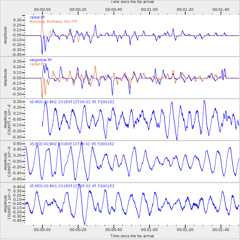
MSO Missoula, Montana, USA - Earthquake Result Viewer
*The percent match for this event was below the threshold and hence no stack was calculated.
| Earthquake location: |
Tonga Islands |
| Earthquake latitude/longitude: |
-21.2/-173.9 |
| Earthquake time(UTC): |
2018/05/13 (133) 05:50:33 GMT |
| Earthquake Depth: |
10 km |
| Earthquake Magnitude: |
5.6 mb |
| Earthquake Catalog/Contributor: |
NEIC PDE/us |
|
| Network: |
US United States National Seismic Network |
| Station: |
MSO Missoula, Montana, USA |
| Lat/Lon: |
46.83 N/113.94 W |
| Elevation: |
1264 m |
|
| Distance: |
86.6 deg |
| Az: |
36.534 deg |
| Baz: |
234.022 deg |
| Ray Param: |
$rayparam |
*The percent match for this event was below the threshold and hence was not used in the summary stack. |
|
| Radial Match: |
52.577705 % |
| Radial Bump: |
400 |
| Transverse Match: |
50.71838 % |
| Transverse Bump: |
400 |
| SOD ConfigId: |
2665671 |
| Insert Time: |
2018-05-27 05:58:20.777 +0000 |
| GWidth: |
2.5 |
| Max Bumps: |
400 |
| Tol: |
0.001 |
|
Signal To Noise
| Channel | StoN | STA | LTA |
| US:MSO:00:BHZ:20180513T06:02:45.599016Z | 1.7446754 | 3.8179118E-7 | 2.1883221E-7 |
| US:MSO:00:BH1:20180513T06:02:45.599016Z | 0.99451077 | 1.0776091E-7 | 1.083557E-7 |
| US:MSO:00:BH2:20180513T06:02:45.599016Z | 0.7008928 | 1.0012074E-7 | 1.4284743E-7 |
| Arrivals |
| Ps | |
| PpPs | |
| PsPs/PpSs | |


