You are here: Home > Network List > BK - Berkeley Digital Seismograph Network Stations List
> Station HUMO Hull Mountain, OR > Earthquake Result Viewer
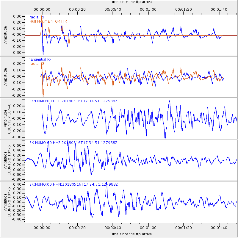
HUMO Hull Mountain, OR - Earthquake Result Viewer
*The percent match for this event was below the threshold and hence no stack was calculated.
| Earthquake location: |
South Of Kermadec Islands |
| Earthquake latitude/longitude: |
-33.9/-179.5 |
| Earthquake time(UTC): |
2018/05/16 (136) 17:22:13 GMT |
| Earthquake Depth: |
10 km |
| Earthquake Magnitude: |
5.8 Mww |
| Earthquake Catalog/Contributor: |
NEIC PDE/us |
|
| Network: |
BK Berkeley Digital Seismograph Network |
| Station: |
HUMO Hull Mountain, OR |
| Lat/Lon: |
42.61 N/122.96 W |
| Elevation: |
555 m |
|
| Distance: |
92.1 deg |
| Az: |
38.072 deg |
| Baz: |
223.995 deg |
| Ray Param: |
$rayparam |
*The percent match for this event was below the threshold and hence was not used in the summary stack. |
|
| Radial Match: |
61.670197 % |
| Radial Bump: |
400 |
| Transverse Match: |
74.97278 % |
| Transverse Bump: |
400 |
| SOD ConfigId: |
2665671 |
| Insert Time: |
2018-05-30 17:27:00.096 +0000 |
| GWidth: |
2.5 |
| Max Bumps: |
400 |
| Tol: |
0.001 |
|
Signal To Noise
| Channel | StoN | STA | LTA |
| BK:HUMO:00:HHZ:20180516T17:34:51.127988Z | 2.6166828 | 3.3799657E-7 | 1.2916986E-7 |
| BK:HUMO:00:HHN:20180516T17:34:51.127988Z | 0.9353499 | 1.0055446E-7 | 1.0750465E-7 |
| BK:HUMO:00:HHE:20180516T17:34:51.127988Z | 1.0303692 | 1.0183474E-7 | 9.883327E-8 |
| Arrivals |
| Ps | |
| PpPs | |
| PsPs/PpSs | |


