You are here: Home > Network List > AV - Alaska Volcano Observatory Stations List
> Station SPCR Ckakachatna River, Mount Spurr, Alaska > Earthquake Result Viewer
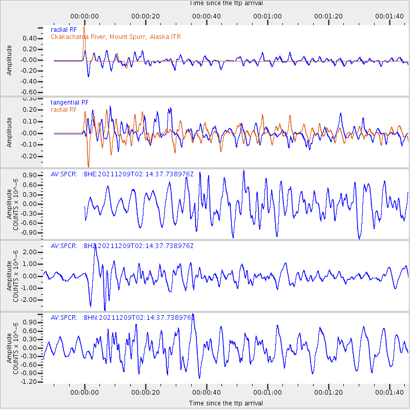
SPCR Ckakachatna River, Mount Spurr, Alaska - Earthquake Result Viewer
*The percent match for this event was below the threshold and hence no stack was calculated.
| Earthquake location: |
Ryukyu Islands, Japan |
| Earthquake latitude/longitude: |
29.4/129.4 |
| Earthquake time(UTC): |
2021/12/09 (343) 02:05:07 GMT |
| Earthquake Depth: |
10 km |
| Earthquake Magnitude: |
5.9 Mww |
| Earthquake Catalog/Contributor: |
NEIC PDE/us |
|
| Network: |
AV Alaska Volcano Observatory |
| Station: |
SPCR Ckakachatna River, Mount Spurr, Alaska |
| Lat/Lon: |
61.20 N/152.21 W |
| Elevation: |
984 m |
|
| Distance: |
59.2 deg |
| Az: |
33.53 deg |
| Baz: |
275.541 deg |
| Ray Param: |
$rayparam |
*The percent match for this event was below the threshold and hence was not used in the summary stack. |
|
| Radial Match: |
60.628582 % |
| Radial Bump: |
400 |
| Transverse Match: |
69.33043 % |
| Transverse Bump: |
400 |
| SOD ConfigId: |
26694651 |
| Insert Time: |
2021-12-23 02:12:13.930 +0000 |
| GWidth: |
2.5 |
| Max Bumps: |
400 |
| Tol: |
0.001 |
|
Signal To Noise
| Channel | StoN | STA | LTA |
| AV:SPCR: :BHZ:20211209T02:14:37.738976Z | 3.8534892 | 1.3520536E-6 | 3.5086478E-7 |
| AV:SPCR: :BHN:20211209T02:14:37.738976Z | 0.7596346 | 2.2438782E-7 | 2.9538913E-7 |
| AV:SPCR: :BHE:20211209T02:14:37.738976Z | 1.4671053 | 4.4468769E-7 | 3.031055E-7 |
| Arrivals |
| Ps | |
| PpPs | |
| PsPs/PpSs | |


