You are here: Home > Network List > GS - US Geological Survey Networks Stations List
> Station KAN13 Rinehart Farm > Earthquake Result Viewer
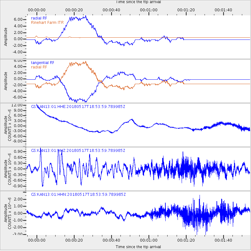
KAN13 Rinehart Farm - Earthquake Result Viewer
*The percent match for this event was below the threshold and hence no stack was calculated.
| Earthquake location: |
Hokkaido, Japan Region |
| Earthquake latitude/longitude: |
42.7/145.6 |
| Earthquake time(UTC): |
2018/05/17 (137) 18:42:10 GMT |
| Earthquake Depth: |
10 km |
| Earthquake Magnitude: |
5.8 Mww |
| Earthquake Catalog/Contributor: |
NEIC PDE/us |
|
| Network: |
GS US Geological Survey Networks |
| Station: |
KAN13 Rinehart Farm |
| Lat/Lon: |
37.01 N/97.48 W |
| Elevation: |
340 m |
|
| Distance: |
82.1 deg |
| Az: |
46.101 deg |
| Baz: |
318.404 deg |
| Ray Param: |
$rayparam |
*The percent match for this event was below the threshold and hence was not used in the summary stack. |
|
| Radial Match: |
48.551105 % |
| Radial Bump: |
400 |
| Transverse Match: |
46.747486 % |
| Transverse Bump: |
400 |
| SOD ConfigId: |
2665671 |
| Insert Time: |
2018-05-31 18:48:35.518 +0000 |
| GWidth: |
2.5 |
| Max Bumps: |
400 |
| Tol: |
0.001 |
|
Signal To Noise
| Channel | StoN | STA | LTA |
| GS:KAN13:01:HHZ:20180517T18:53:59.789985Z | 5.139324 | 4.574014E-7 | 8.90003E-8 |
| GS:KAN13:01:HHN:20180517T18:53:59.789985Z | 0.50361013 | 3.2069858E-7 | 6.3679926E-7 |
| GS:KAN13:01:HHE:20180517T18:53:59.789985Z | 2.0641868 | 7.2221796E-6 | 3.4988013E-6 |
| Arrivals |
| Ps | |
| PpPs | |
| PsPs/PpSs | |


