You are here: Home > Network List > IU - Global Seismograph Network (GSN - IRIS/USGS) Stations List
> Station JOHN Johnston Island, USA > Earthquake Result Viewer
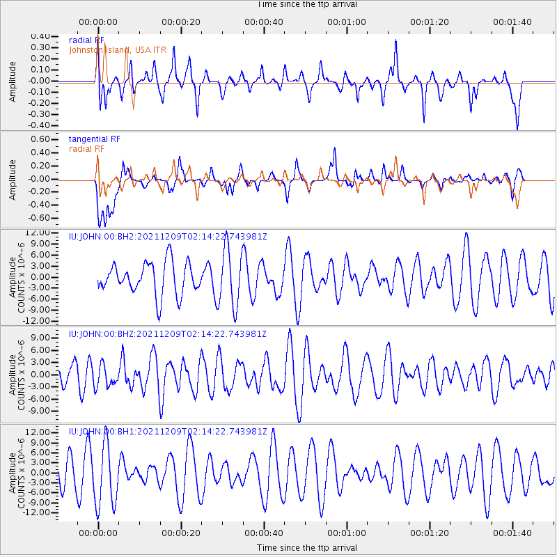
JOHN Johnston Island, USA - Earthquake Result Viewer
*The percent match for this event was below the threshold and hence no stack was calculated.
| Earthquake location: |
Ryukyu Islands, Japan |
| Earthquake latitude/longitude: |
29.4/129.4 |
| Earthquake time(UTC): |
2021/12/09 (343) 02:05:07 GMT |
| Earthquake Depth: |
10 km |
| Earthquake Magnitude: |
5.9 Mww |
| Earthquake Catalog/Contributor: |
NEIC PDE/us |
|
| Network: |
IU Global Seismograph Network (GSN - IRIS/USGS) |
| Station: |
JOHN Johnston Island, USA |
| Lat/Lon: |
16.73 N/169.53 W |
| Elevation: |
2.0 m |
|
| Distance: |
57.0 deg |
| Az: |
88.412 deg |
| Baz: |
294.455 deg |
| Ray Param: |
$rayparam |
*The percent match for this event was below the threshold and hence was not used in the summary stack. |
|
| Radial Match: |
43.541687 % |
| Radial Bump: |
371 |
| Transverse Match: |
35.50889 % |
| Transverse Bump: |
400 |
| SOD ConfigId: |
26694651 |
| Insert Time: |
2021-12-23 02:19:59.506 +0000 |
| GWidth: |
2.5 |
| Max Bumps: |
400 |
| Tol: |
0.001 |
|
Signal To Noise
| Channel | StoN | STA | LTA |
| IU:JOHN:00:BHZ:20211209T02:14:22.743981Z | 0.69198346 | 2.656925E-6 | 3.8395788E-6 |
| IU:JOHN:00:BH1:20211209T02:14:22.743981Z | 2.65301 | 9.5028345E-6 | 3.5819066E-6 |
| IU:JOHN:00:BH2:20211209T02:14:22.743981Z | 1.8346411 | 7.8885E-6 | 4.299751E-6 |
| Arrivals |
| Ps | |
| PpPs | |
| PsPs/PpSs | |


