You are here: Home > Network List > O2 - Oklahoma Consolidated Temporary Seismic Networks Stations List
> Station PW19 Marland, Oklahoma, USA > Earthquake Result Viewer
PW19 Marland, Oklahoma, USA - Earthquake Result Viewer
| Earthquake location: |
Near Coast Of Central Chile |
| Earthquake latitude/longitude: |
-29.5/-71.2 |
| Earthquake time(UTC): |
2021/12/11 (345) 14:54:19 GMT |
| Earthquake Depth: |
53 km |
| Earthquake Magnitude: |
5.7 Mww |
| Earthquake Catalog/Contributor: |
NEIC PDE/us |
|
| Network: |
O2 Oklahoma Consolidated Temporary Seismic Networks |
| Station: |
PW19 Marland, Oklahoma, USA |
| Lat/Lon: |
36.57 N/97.04 W |
| Elevation: |
301 m |
|
| Distance: |
70.1 deg |
| Az: |
338.091 deg |
| Baz: |
156.18 deg |
| Ray Param: |
0.05511187 |
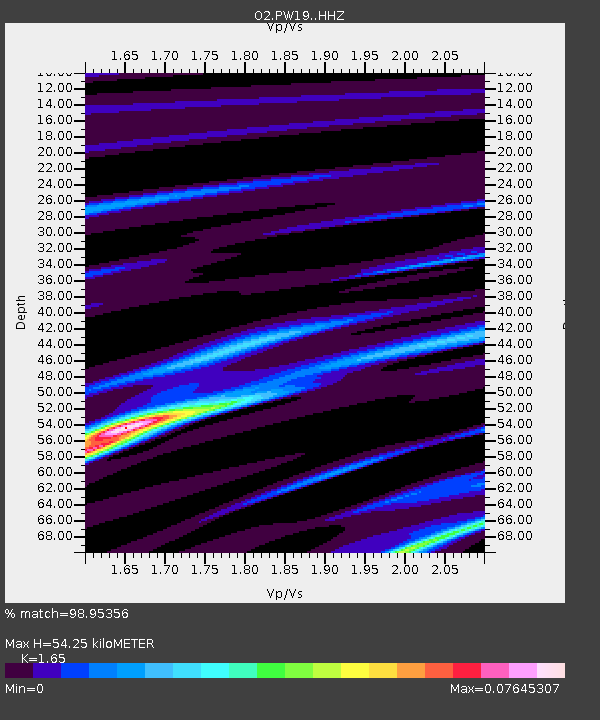
| Estimated Moho Depth: |
54.25 km |
| Estimated Crust Vp/Vs: |
1.65 |
| Assumed Crust Vp: |
6.483 km/s |
| Estimated Crust Vs: |
3.929 km/s |
| Estimated Crust Poisson's Ratio: |
0.21 |
|
| Radial Match: |
98.95356 % |
| Radial Bump: |
76 |
| Transverse Match: |
98.95356 % |
| Transverse Bump: |
76 |
| SOD ConfigId: |
26694651 |
| Insert Time: |
2021-12-25 15:05:48.026 +0000 |
| GWidth: |
2.5 |
| Max Bumps: |
400 |
| Tol: |
0.001 |
|

Signal To Noise
| Channel | StoN | STA | LTA |
| O2:PW19: :HHZ:20211211T15:04:55.370025Z | 3.055059 | 5.2980977E-7 | 1.7342047E-7 |
| $trig.getChannelId() | $trig.getValue() | $trig.getSTA() | $trig.getLTA() |
| O2:PW19: :HHE:20211211T15:04:55.370025Z | 3.0162501 | 7.4617606E-7 | 2.4738534E-7 |
| Arrivals |
| Ps | 5.7 SECOND |
| PpPs | 21 SECOND |
| PsPs/PpSs | 27 SECOND |


