You are here: Home > Network List > US - United States National Seismic Network Stations List
> Station WMOK Wichita Mountains, Oklahoma, USA > Earthquake Result Viewer
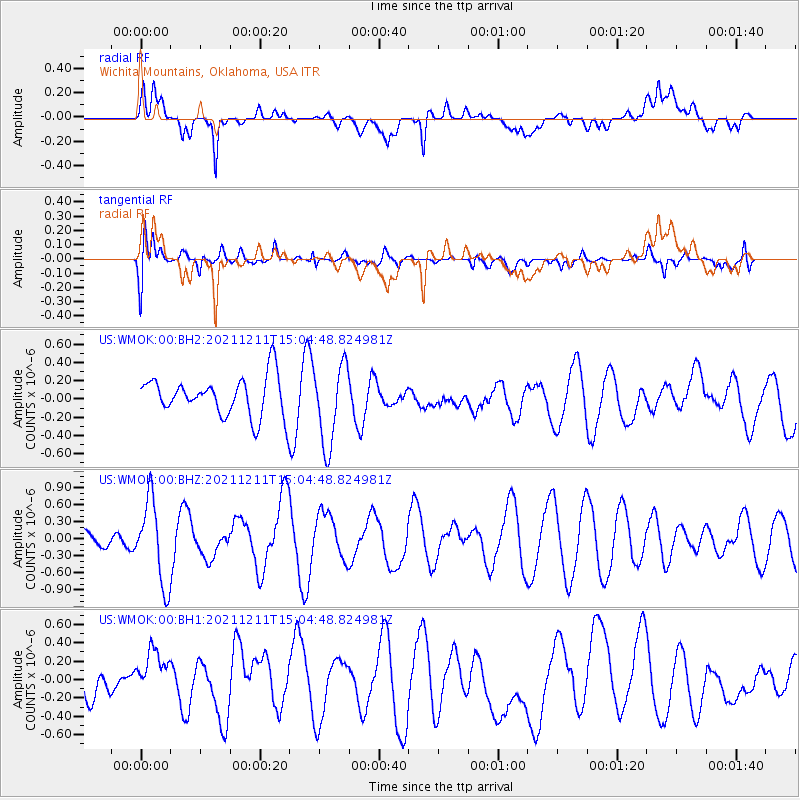
WMOK Wichita Mountains, Oklahoma, USA - Earthquake Result Viewer
*The percent match for this event was below the threshold and hence no stack was calculated.
| Earthquake location: |
Near Coast Of Central Chile |
| Earthquake latitude/longitude: |
-29.5/-71.2 |
| Earthquake time(UTC): |
2021/12/11 (345) 14:54:19 GMT |
| Earthquake Depth: |
53 km |
| Earthquake Magnitude: |
5.7 Mww |
| Earthquake Catalog/Contributor: |
NEIC PDE/us |
|
| Network: |
US United States National Seismic Network |
| Station: |
WMOK Wichita Mountains, Oklahoma, USA |
| Lat/Lon: |
34.74 N/98.78 W |
| Elevation: |
486 m |
|
| Distance: |
69.0 deg |
| Az: |
335.898 deg |
| Baz: |
154.402 deg |
| Ray Param: |
$rayparam |
*The percent match for this event was below the threshold and hence was not used in the summary stack. |
|
| Radial Match: |
65.18055 % |
| Radial Bump: |
400 |
| Transverse Match: |
63.466167 % |
| Transverse Bump: |
400 |
| SOD ConfigId: |
26694651 |
| Insert Time: |
2021-12-25 15:10:47.619 +0000 |
| GWidth: |
2.5 |
| Max Bumps: |
400 |
| Tol: |
0.001 |
|
Signal To Noise
| Channel | StoN | STA | LTA |
| US:WMOK:00:BHZ:20211211T15:04:48.824981Z | 2.6475003 | 7.286656E-7 | 2.7522776E-7 |
| US:WMOK:00:BH1:20211211T15:04:48.824981Z | 1.4129223 | 2.9761858E-7 | 2.1064045E-7 |
| US:WMOK:00:BH2:20211211T15:04:48.824981Z | 2.0661018 | 4.4291642E-7 | 2.14373E-7 |
| Arrivals |
| Ps | |
| PpPs | |
| PsPs/PpSs | |


