You are here: Home > Network List > XE05 - Sierra Nevada EarthScope Project- EarthScope Flex Array Stations List
> Station SNP21 SNP21 > Earthquake Result Viewer
SNP21 SNP21 - Earthquake Result Viewer
| Earthquake location: |
New Ireland Region, P.N.G. |
| Earthquake latitude/longitude: |
-4.5/153.5 |
| Earthquake time(UTC): |
2005/09/09 (252) 07:26:43 GMT |
| Earthquake Depth: |
90 km |
| Earthquake Magnitude: |
6.3 MB, 7.7 MW, 7.5 MW |
| Earthquake Catalog/Contributor: |
WHDF/NEIC |
|
| Network: |
XE Sierra Nevada EarthScope Project- EarthScope Flex Array |
| Station: |
SNP21 SNP21 |
| Lat/Lon: |
36.82 N/119.51 W |
| Elevation: |
229 m |
|
| Distance: |
90.3 deg |
| Az: |
53.261 deg |
| Baz: |
264.602 deg |
| Ray Param: |
0.04166612 |
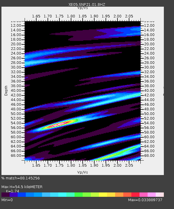
| Estimated Moho Depth: |
54.5 km |
| Estimated Crust Vp/Vs: |
1.74 |
| Assumed Crust Vp: |
6.291 km/s |
| Estimated Crust Vs: |
3.616 km/s |
| Estimated Crust Poisson's Ratio: |
0.25 |
|
| Radial Match: |
88.145256 % |
| Radial Bump: |
400 |
| Transverse Match: |
88.14528 % |
| Transverse Bump: |
400 |
| SOD ConfigId: |
268666 |
| Insert Time: |
2010-03-09 15:00:59.107 +0000 |
| GWidth: |
2.5 |
| Max Bumps: |
400 |
| Tol: |
0.001 |
|

Signal To Noise
| Channel | StoN | STA | LTA |
| XE:SNP21:01:BHZ:20050909T07:39:03.339009Z | 12.986285 | 1.1610925E-6 | 8.9409134E-8 |
| XE:SNP21:01:BHN:20050909T07:39:03.339009Z | 1.1342056 | 7.90017E-8 | 6.965377E-8 |
| $trig.getChannelId() | $trig.getValue() | $trig.getSTA() | $trig.getLTA() |
| Arrivals |
| Ps | 6.5 SECOND |
| PpPs | 23 SECOND |
| PsPs/PpSs | 30 SECOND |


