You are here: Home > Network List > XE05 - Sierra Nevada EarthScope Project- EarthScope Flex Array Stations List
> Station SNP21 SNP21 > Earthquake Result Viewer
SNP21 SNP21 - Earthquake Result Viewer
| Earthquake location: |
Northern Peru |
| Earthquake latitude/longitude: |
-5.7/-76.4 |
| Earthquake time(UTC): |
2005/09/26 (269) 01:55:37 GMT |
| Earthquake Depth: |
115 km |
| Earthquake Magnitude: |
6.7 MB, 7.5 MW, 7.5 MW |
| Earthquake Catalog/Contributor: |
WHDF/NEIC |
|
| Network: |
XE Sierra Nevada EarthScope Project- EarthScope Flex Array |
| Station: |
SNP21 SNP21 |
| Lat/Lon: |
36.82 N/119.51 W |
| Elevation: |
229 m |
|
| Distance: |
58.4 deg |
| Az: |
319.905 deg |
| Baz: |
126.99 deg |
| Ray Param: |
0.06253927 |
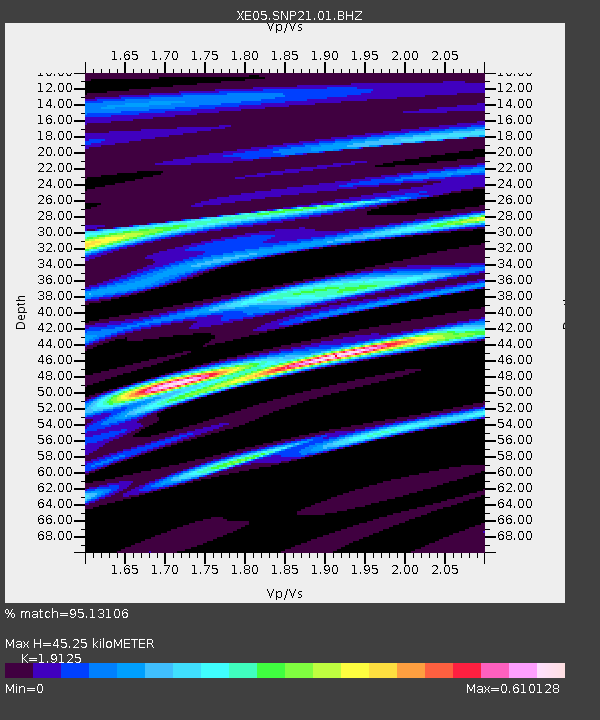
| Estimated Moho Depth: |
45.25 km |
| Estimated Crust Vp/Vs: |
1.91 |
| Assumed Crust Vp: |
6.291 km/s |
| Estimated Crust Vs: |
3.29 km/s |
| Estimated Crust Poisson's Ratio: |
0.31 |
|
| Radial Match: |
95.13106 % |
| Radial Bump: |
400 |
| Transverse Match: |
90.312126 % |
| Transverse Bump: |
400 |
| SOD ConfigId: |
268666 |
| Insert Time: |
2010-03-09 15:01:03.201 +0000 |
| GWidth: |
2.5 |
| Max Bumps: |
400 |
| Tol: |
0.001 |
|

Signal To Noise
| Channel | StoN | STA | LTA |
| XE:SNP21:01:BHZ:20050926T02:04:50.339006Z | 56.242695 | 1.5004854E-5 | 2.667876E-7 |
| XE:SNP21:01:BHN:20050926T02:04:50.339006Z | 44.7302 | 4.8863117E-6 | 1.0923965E-7 |
| XE:SNP21:01:BHE:20050926T02:04:50.339006Z | 28.628944 | 5.0593135E-6 | 1.7672022E-7 |
| Arrivals |
| Ps | 6.8 SECOND |
| PpPs | 20 SECOND |
| PsPs/PpSs | 27 SECOND |


