You are here: Home > Network List > IU - Global Seismograph Network (GSN - IRIS/USGS) Stations List
> Station KIP Kipapa, Hawaii, USA > Earthquake Result Viewer
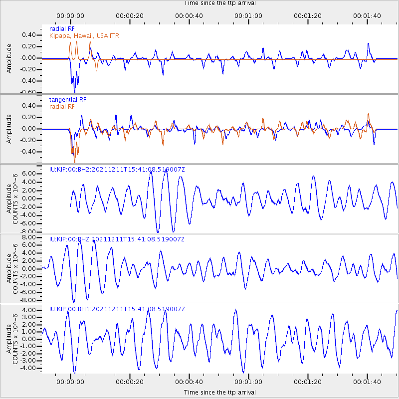
KIP Kipapa, Hawaii, USA - Earthquake Result Viewer
*The percent match for this event was below the threshold and hence no stack was calculated.
| Earthquake location: |
Banda Sea |
| Earthquake latitude/longitude: |
-7.1/128.7 |
| Earthquake time(UTC): |
2021/12/11 (345) 15:29:45 GMT |
| Earthquake Depth: |
10 km |
| Earthquake Magnitude: |
5.6 mww |
| Earthquake Catalog/Contributor: |
NEIC PDE/us |
|
| Network: |
IU Global Seismograph Network (GSN - IRIS/USGS) |
| Station: |
KIP Kipapa, Hawaii, USA |
| Lat/Lon: |
21.42 N/158.01 W |
| Elevation: |
70 m |
|
| Distance: |
77.2 deg |
| Az: |
66.221 deg |
| Baz: |
257.102 deg |
| Ray Param: |
$rayparam |
*The percent match for this event was below the threshold and hence was not used in the summary stack. |
|
| Radial Match: |
56.686268 % |
| Radial Bump: |
400 |
| Transverse Match: |
67.71704 % |
| Transverse Bump: |
400 |
| SOD ConfigId: |
26694651 |
| Insert Time: |
2021-12-25 15:34:21.133 +0000 |
| GWidth: |
2.5 |
| Max Bumps: |
400 |
| Tol: |
0.001 |
|
Signal To Noise
| Channel | StoN | STA | LTA |
| IU:KIP:00:BHZ:20211211T15:41:08.519007Z | 2.3542843 | 5.249346E-6 | 2.2296995E-6 |
| IU:KIP:00:BH1:20211211T15:41:08.519007Z | 1.672181 | 2.7425947E-6 | 1.6401302E-6 |
| IU:KIP:00:BH2:20211211T15:41:08.519007Z | 2.8665943 | 5.635583E-6 | 1.9659506E-6 |
| Arrivals |
| Ps | |
| PpPs | |
| PsPs/PpSs | |


