You are here: Home > Network List > CI - Caltech Regional Seismic Network Stations List
> Station EDW2 EDW2, Mojave, CA, USA > Earthquake Result Viewer
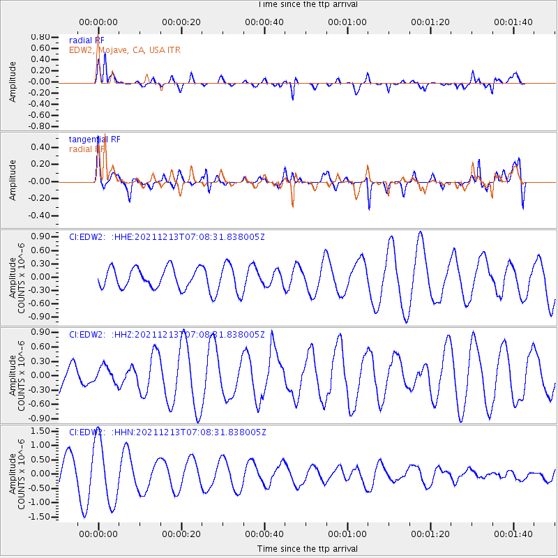
EDW2 EDW2, Mojave, CA, USA - Earthquake Result Viewer
*The percent match for this event was below the threshold and hence no stack was calculated.
| Earthquake location: |
Mexico-Guatemala Border Region |
| Earthquake latitude/longitude: |
15.6/-92.0 |
| Earthquake time(UTC): |
2021/12/13 (347) 07:03:08 GMT |
| Earthquake Depth: |
180 km |
| Earthquake Magnitude: |
5.7 mww |
| Earthquake Catalog/Contributor: |
NEIC PDE/us |
|
| Network: |
CI Caltech Regional Seismic Network |
| Station: |
EDW2 EDW2, Mojave, CA, USA |
| Lat/Lon: |
34.88 N/117.99 W |
| Elevation: |
772 m |
|
| Distance: |
30.2 deg |
| Az: |
314.355 deg |
| Baz: |
123.041 deg |
| Ray Param: |
$rayparam |
*The percent match for this event was below the threshold and hence was not used in the summary stack. |
|
| Radial Match: |
60.558346 % |
| Radial Bump: |
378 |
| Transverse Match: |
31.97911 % |
| Transverse Bump: |
400 |
| SOD ConfigId: |
26694651 |
| Insert Time: |
2021-12-27 07:09:53.681 +0000 |
| GWidth: |
2.5 |
| Max Bumps: |
400 |
| Tol: |
0.001 |
|
Signal To Noise
| Channel | StoN | STA | LTA |
| CI:EDW2: :HHZ:20211213T07:08:31.838005Z | 0.48427427 | 1.7124923E-7 | 3.5362035E-7 |
| CI:EDW2: :HHN:20211213T07:08:31.838005Z | 2.5783913 | 1.1229488E-6 | 4.35523E-7 |
| CI:EDW2: :HHE:20211213T07:08:31.838005Z | 1.5218241 | 3.2726436E-7 | 2.1504744E-7 |
| Arrivals |
| Ps | |
| PpPs | |
| PsPs/PpSs | |


