You are here: Home > Network List > GT - Global Telemetered Seismograph Network (USAF/USGS) Stations List
> Station LPAZ La Paz , Bolivia > Earthquake Result Viewer
LPAZ La Paz , Bolivia - Earthquake Result Viewer
*The percent match for this event was below the threshold and hence no stack was calculated.
| Earthquake location: |
Mexico-Guatemala Border Region |
| Earthquake latitude/longitude: |
15.6/-92.0 |
| Earthquake time(UTC): |
2021/12/13 (347) 07:03:08 GMT |
| Earthquake Depth: |
180 km |
| Earthquake Magnitude: |
5.7 mww |
| Earthquake Catalog/Contributor: |
NEIC PDE/us |
|
| Network: |
GT Global Telemetered Seismograph Network (USAF/USGS) |
| Station: |
LPAZ La Paz , Bolivia |
| Lat/Lon: |
16.17 S/68.08 W |
| Elevation: |
4817 m |
|
| Distance: |
39.4 deg |
| Az: |
142.066 deg |
| Baz: |
321.93 deg |
| Ray Param: |
$rayparam |
*The percent match for this event was below the threshold and hence was not used in the summary stack. |
|
| Radial Match: |
34.723057 % |
| Radial Bump: |
400 |
| Transverse Match: |
55.191944 % |
| Transverse Bump: |
400 |
| SOD ConfigId: |
26694651 |
| Insert Time: |
2021-12-27 07:12:27.551 +0000 |
| GWidth: |
2.5 |
| Max Bumps: |
400 |
| Tol: |
0.001 |
|
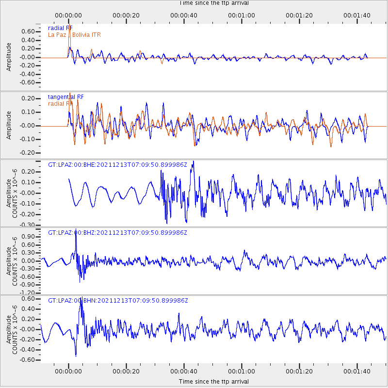
Signal To Noise
| Channel | StoN | STA | LTA |
| GT:LPAZ:00:BHZ:20211213T07:09:50.899986Z | 2.8625903 | 3.6409375E-7 | 1.2719032E-7 |
| GT:LPAZ:00:BHN:20211213T07:09:50.899986Z | 2.4389806 | 2.7563243E-7 | 1.1301133E-7 |
| GT:LPAZ:00:BHE:20211213T07:09:50.899986Z | 1.645194 | 1.0252309E-7 | 6.2316715E-8 |
| Arrivals |
| Ps | |
| PpPs | |
| PsPs/PpSs | |


