You are here: Home > Network List > UW - Pacific Northwest Regional Seismic Network Stations List
> Station IRON Crane, OR, USA > Earthquake Result Viewer
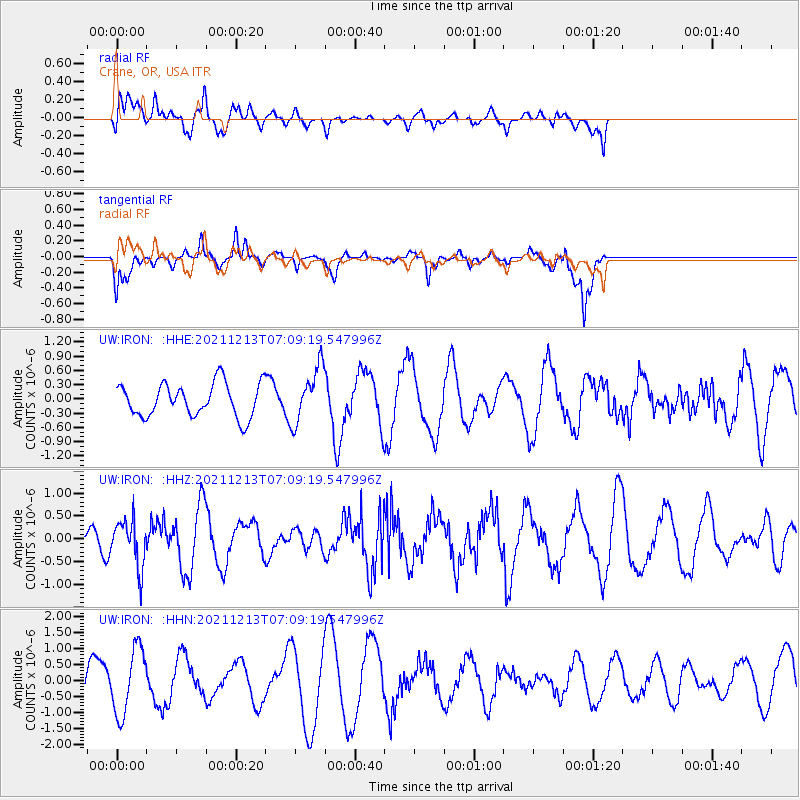
IRON Crane, OR, USA - Earthquake Result Viewer
*The percent match for this event was below the threshold and hence no stack was calculated.
| Earthquake location: |
Mexico-Guatemala Border Region |
| Earthquake latitude/longitude: |
15.6/-92.0 |
| Earthquake time(UTC): |
2021/12/13 (347) 07:03:08 GMT |
| Earthquake Depth: |
180 km |
| Earthquake Magnitude: |
5.7 mww |
| Earthquake Catalog/Contributor: |
NEIC PDE/us |
|
| Network: |
UW Pacific Northwest Regional Seismic Network |
| Station: |
IRON Crane, OR, USA |
| Lat/Lon: |
43.36 N/118.47 W |
| Elevation: |
1226 m |
|
| Distance: |
35.7 deg |
| Az: |
326.222 deg |
| Baz: |
132.717 deg |
| Ray Param: |
$rayparam |
*The percent match for this event was below the threshold and hence was not used in the summary stack. |
|
| Radial Match: |
69.099144 % |
| Radial Bump: |
400 |
| Transverse Match: |
61.800743 % |
| Transverse Bump: |
325 |
| SOD ConfigId: |
26694651 |
| Insert Time: |
2021-12-27 07:16:58.829 +0000 |
| GWidth: |
2.5 |
| Max Bumps: |
400 |
| Tol: |
0.001 |
|
Signal To Noise
| Channel | StoN | STA | LTA |
| UW:IRON: :HHZ:20211213T07:09:19.547996Z | 1.3571911 | 5.146462E-7 | 3.7919952E-7 |
| UW:IRON: :HHN:20211213T07:09:19.547996Z | 2.5708783 | 1.0371836E-6 | 4.0343548E-7 |
| UW:IRON: :HHE:20211213T07:09:19.547996Z | 1.6858196 | 5.8756905E-7 | 3.4853613E-7 |
| Arrivals |
| Ps | |
| PpPs | |
| PsPs/PpSs | |


