You are here: Home > Network List > YL01 - Himalayan Nepal Tibet Experiment Stations List
> Station SSAN YL.SSAN > Earthquake Result Viewer
SSAN YL.SSAN - Earthquake Result Viewer
| Earthquake location: |
Bonin Islands, Japan Region |
| Earthquake latitude/longitude: |
27.6/139.8 |
| Earthquake time(UTC): |
2002/06/03 (154) 09:15:00 GMT |
| Earthquake Depth: |
489 km |
| Earthquake Magnitude: |
5.0 MB, 5.9 MW, 5.9 MW |
| Earthquake Catalog/Contributor: |
WHDF/NEIC |
|
| Network: |
YL Himalayan Nepal Tibet Experiment |
| Station: |
SSAN YL.SSAN |
| Lat/Lon: |
29.42 N/86.73 E |
| Elevation: |
4585 m |
|
| Distance: |
46.3 deg |
| Az: |
285.436 deg |
| Baz: |
78.779 deg |
| Ray Param: |
0.068472564 |
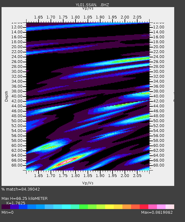
| Estimated Moho Depth: |
66.25 km |
| Estimated Crust Vp/Vs: |
1.76 |
| Assumed Crust Vp: |
6.514 km/s |
| Estimated Crust Vs: |
3.696 km/s |
| Estimated Crust Poisson's Ratio: |
0.26 |
|
| Radial Match: |
84.39042 % |
| Radial Bump: |
400 |
| Transverse Match: |
78.88117 % |
| Transverse Bump: |
400 |
| SOD ConfigId: |
16844 |
| Insert Time: |
2010-02-26 16:14:13.747 +0000 |
| GWidth: |
2.5 |
| Max Bumps: |
400 |
| Tol: |
0.001 |
|

Signal To Noise
| Channel | StoN | STA | LTA |
| YL:SSAN: :BHZ:20020603T09:22:11.115985Z | 6.625227 | 2.7031038E-7 | 4.0800167E-8 |
| YL:SSAN: :BHN:20020603T09:22:11.115985Z | 1.0783936 | 4.2605464E-8 | 3.950827E-8 |
| YL:SSAN: :BHE:20020603T09:22:11.115985Z | 3.464858 | 1.2388723E-7 | 3.575536E-8 |
| Arrivals |
| Ps | 8.2 SECOND |
| PpPs | 26 SECOND |
| PsPs/PpSs | 35 SECOND |


