You are here: Home > Network List > G - GEOSCOPE Stations List
> Station DRV Dumont d'Urville, Terre Adelie (Antartica) > Earthquake Result Viewer
DRV Dumont d'Urville, Terre Adelie (Antartica) - Earthquake Result Viewer
| Earthquake location: |
Flores Sea |
| Earthquake latitude/longitude: |
-7.8/122.3 |
| Earthquake time(UTC): |
2021/12/14 (348) 03:20:24 GMT |
| Earthquake Depth: |
76 km |
| Earthquake Magnitude: |
7.6 Mi |
| Earthquake Catalog/Contributor: |
NEIC PDE/at |
|
| Network: |
G GEOSCOPE |
| Station: |
DRV Dumont d'Urville, Terre Adelie (Antartica) |
| Lat/Lon: |
66.67 S/140.01 E |
| Elevation: |
40 m |
|
| Distance: |
60.0 deg |
| Az: |
171.958 deg |
| Baz: |
339.636 deg |
| Ray Param: |
0.06161202 |
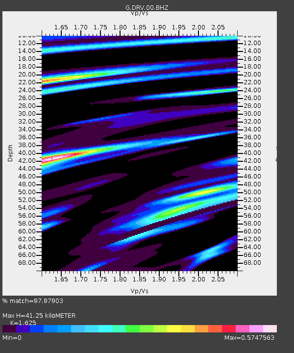
| Estimated Moho Depth: |
41.25 km |
| Estimated Crust Vp/Vs: |
1.62 |
| Assumed Crust Vp: |
6.39 km/s |
| Estimated Crust Vs: |
3.932 km/s |
| Estimated Crust Poisson's Ratio: |
0.20 |
|
| Radial Match: |
97.97903 % |
| Radial Bump: |
256 |
| Transverse Match: |
88.65979 % |
| Transverse Bump: |
400 |
| SOD ConfigId: |
26694651 |
| Insert Time: |
2021-12-28 03:24:09.920 +0000 |
| GWidth: |
2.5 |
| Max Bumps: |
400 |
| Tol: |
0.001 |
|
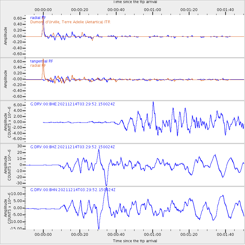
Signal To Noise
| Channel | StoN | STA | LTA |
| G:DRV:00:BHZ:20211214T03:29:52.150024Z | 1.8550168 | 2.700589E-7 | 1.45583E-7 |
| G:DRV:00:BHN:20211214T03:29:52.150024Z | 2.088292 | 2.2324191E-7 | 1.0690169E-7 |
| G:DRV:00:BHE:20211214T03:29:52.150024Z | 1.1666628 | 1.00604176E-7 | 8.623243E-8 |
| Arrivals |
| Ps | 4.2 SECOND |
| PpPs | 16 SECOND |
| PsPs/PpSs | 20 SECOND |


