You are here: Home > Network List > AK - Alaska Regional Network Stations List
> Station G17K Kiwalik Mountain, AK, USA > Earthquake Result Viewer
G17K Kiwalik Mountain, AK, USA - Earthquake Result Viewer
| Earthquake location: |
Flores Sea |
| Earthquake latitude/longitude: |
-7.6/122.2 |
| Earthquake time(UTC): |
2021/12/14 (348) 03:23:30 GMT |
| Earthquake Depth: |
10 km |
| Earthquake Magnitude: |
5.7 mb |
| Earthquake Catalog/Contributor: |
NEIC PDE/us |
|
| Network: |
AK Alaska Regional Network |
| Station: |
G17K Kiwalik Mountain, AK, USA |
| Lat/Lon: |
65.50 N/160.65 W |
| Elevation: |
338 m |
|
| Distance: |
91.6 deg |
| Az: |
23.998 deg |
| Baz: |
255.218 deg |
| Ray Param: |
0.0415913 |
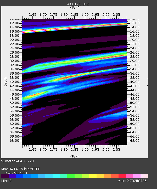
| Estimated Moho Depth: |
14.75 km |
| Estimated Crust Vp/Vs: |
1.73 |
| Assumed Crust Vp: |
6.276 km/s |
| Estimated Crust Vs: |
3.622 km/s |
| Estimated Crust Poisson's Ratio: |
0.25 |
|
| Radial Match: |
84.75728 % |
| Radial Bump: |
382 |
| Transverse Match: |
50.35535 % |
| Transverse Bump: |
400 |
| SOD ConfigId: |
26694651 |
| Insert Time: |
2021-12-28 03:27:20.952 +0000 |
| GWidth: |
2.5 |
| Max Bumps: |
400 |
| Tol: |
0.001 |
|

Signal To Noise
| Channel | StoN | STA | LTA |
| AK:G17K: :BHZ:20211214T03:36:05.640Z | 0.8554614 | 1.1926876E-6 | 1.3942039E-6 |
| AK:G17K: :BHN:20211214T03:36:05.640Z | 2.9252589 | 1.2168883E-6 | 4.1599338E-7 |
| AK:G17K: :BHE:20211214T03:36:05.640Z | 1.1866616 | 6.6291057E-7 | 5.586349E-7 |
| Arrivals |
| Ps | 1.8 SECOND |
| PpPs | 6.3 SECOND |
| PsPs/PpSs | 8.1 SECOND |


