You are here: Home > Network List > US - United States National Seismic Network Stations List
> Station WMOK Wichita Mountains, Oklahoma, USA > Earthquake Result Viewer
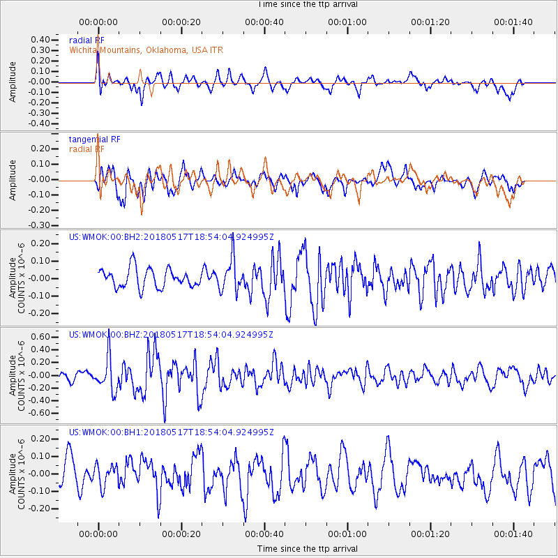
WMOK Wichita Mountains, Oklahoma, USA - Earthquake Result Viewer
*The percent match for this event was below the threshold and hence no stack was calculated.
| Earthquake location: |
Hokkaido, Japan Region |
| Earthquake latitude/longitude: |
42.7/145.6 |
| Earthquake time(UTC): |
2018/05/17 (137) 18:42:10 GMT |
| Earthquake Depth: |
10 km |
| Earthquake Magnitude: |
5.8 Mww |
| Earthquake Catalog/Contributor: |
NEIC PDE/us |
|
| Network: |
US United States National Seismic Network |
| Station: |
WMOK Wichita Mountains, Oklahoma, USA |
| Lat/Lon: |
34.74 N/98.78 W |
| Elevation: |
486 m |
|
| Distance: |
83.1 deg |
| Az: |
48.422 deg |
| Baz: |
317.944 deg |
| Ray Param: |
$rayparam |
*The percent match for this event was below the threshold and hence was not used in the summary stack. |
|
| Radial Match: |
57.832047 % |
| Radial Bump: |
400 |
| Transverse Match: |
63.57708 % |
| Transverse Bump: |
400 |
| SOD ConfigId: |
2665671 |
| Insert Time: |
2018-05-31 18:53:49.774 +0000 |
| GWidth: |
2.5 |
| Max Bumps: |
400 |
| Tol: |
0.001 |
|
Signal To Noise
| Channel | StoN | STA | LTA |
| US:WMOK:00:BHZ:20180517T18:54:04.924995Z | 3.9505658 | 2.720796E-7 | 6.8871046E-8 |
| US:WMOK:00:BH1:20180517T18:54:04.924995Z | 0.5998546 | 6.155246E-8 | 1.02612304E-7 |
| US:WMOK:00:BH2:20180517T18:54:04.924995Z | 1.7626556 | 9.402068E-8 | 5.3340354E-8 |
| Arrivals |
| Ps | |
| PpPs | |
| PsPs/PpSs | |


