You are here: Home > Network List > AV - Alaska Volcano Observatory Stations List
> Station MAPS Pakushin Southeast, Makushin Volcano, Alaska > Earthquake Result Viewer
MAPS Pakushin Southeast, Makushin Volcano, Alaska - Earthquake Result Viewer

| Earthquake location: |
Banda Sea |
| Earthquake latitude/longitude: |
-7.0/128.7 |
| Earthquake time(UTC): |
2021/12/16 (350) 04:26:07 GMT |
| Earthquake Depth: |
10 km |
| Earthquake Magnitude: |
5.6 Mww |
| Earthquake Catalog/Contributor: |
NEIC PDE/us |
|
| Network: |
AV Alaska Volcano Observatory |
| Station: |
MAPS Pakushin Southeast, Makushin Volcano, Alaska |
| Lat/Lon: |
53.81 N/166.94 W |
| Elevation: |
333 m |
|
| Distance: |
81.0 deg |
| Az: |
32.783 deg |
| Baz: |
244.98 deg |
| Ray Param: |
0.04789118 |
| Estimated Moho Depth: |
24.25 km |
| Estimated Crust Vp/Vs: |
1.93 |
| Assumed Crust Vp: |
3.943 km/s |
| Estimated Crust Vs: |
2.041 km/s |
| Estimated Crust Poisson's Ratio: |
0.32 |
|
| Radial Match: |
92.2373 % |
| Radial Bump: |
253 |
| Transverse Match: |
92.22375 % |
| Transverse Bump: |
378 |
| SOD ConfigId: |
26694651 |
| Insert Time: |
2021-12-30 04:29:26.518 +0000 |
| GWidth: |
2.5 |
| Max Bumps: |
400 |
| Tol: |
0.001 |
|
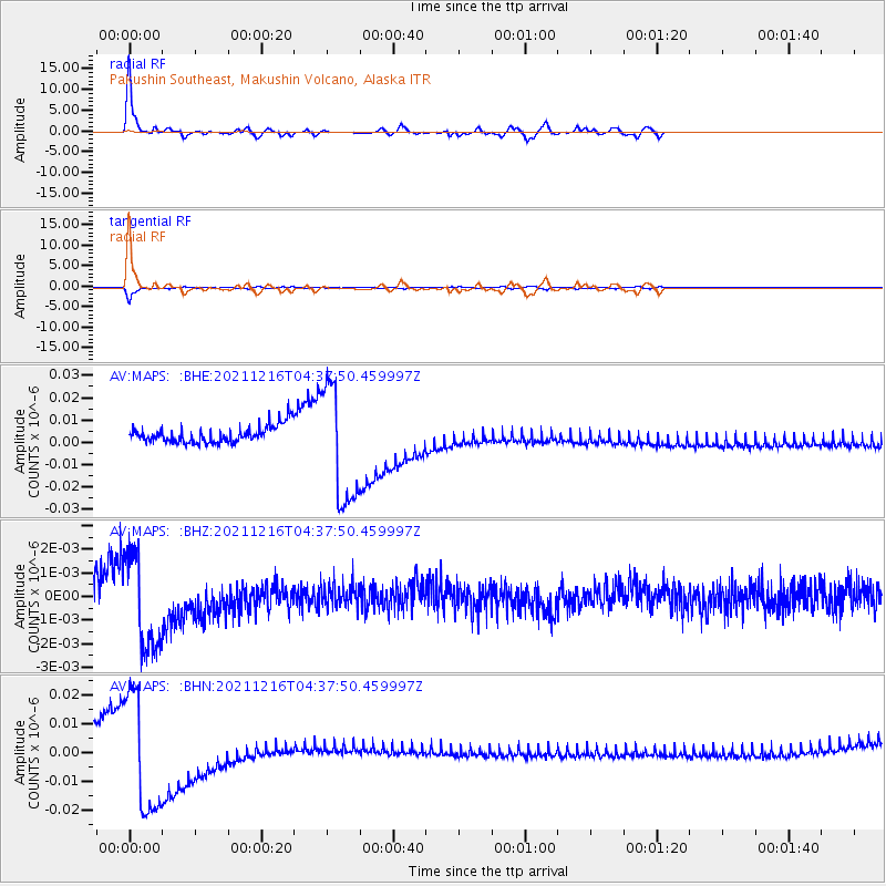
Signal To Noise
| Channel | StoN | STA | LTA |
| AV:MAPS: :BHZ:20211216T04:37:50.459997Z | 3.7446408 | 2.0111306E-9 | 5.3706906E-10 |
| AV:MAPS: :BHN:20211216T04:37:50.459997Z | 6.854278 | 2.0731315E-8 | 3.0245804E-9 |
| AV:MAPS: :BHE:20211216T04:37:50.459997Z | 7.108138 | 2.6832941E-8 | 3.774961E-9 |
| Arrivals |
| Ps | 5.8 SECOND |
| PpPs | 18 SECOND |
| PsPs/PpSs | 24 SECOND |


