You are here: Home > Network List > GT - Global Telemetered Seismograph Network (USAF/USGS) Stations List
> Station PLCA Paso Flores, Argentina > Earthquake Result Viewer
PLCA Paso Flores, Argentina - Earthquake Result Viewer
| Earthquake location: |
South Sandwich Islands Region |
| Earthquake latitude/longitude: |
-60.2/-23.9 |
| Earthquake time(UTC): |
2021/12/16 (350) 21:14:45 GMT |
| Earthquake Depth: |
10 km |
| Earthquake Magnitude: |
6.1 mww |
| Earthquake Catalog/Contributor: |
NEIC PDE/us |
|
| Network: |
GT Global Telemetered Seismograph Network (USAF/USGS) |
| Station: |
PLCA Paso Flores, Argentina |
| Lat/Lon: |
40.73 S/70.55 W |
| Elevation: |
1080 m |
|
| Distance: |
34.6 deg |
| Az: |
282.958 deg |
| Baz: |
140.208 deg |
| Ray Param: |
0.077677906 |
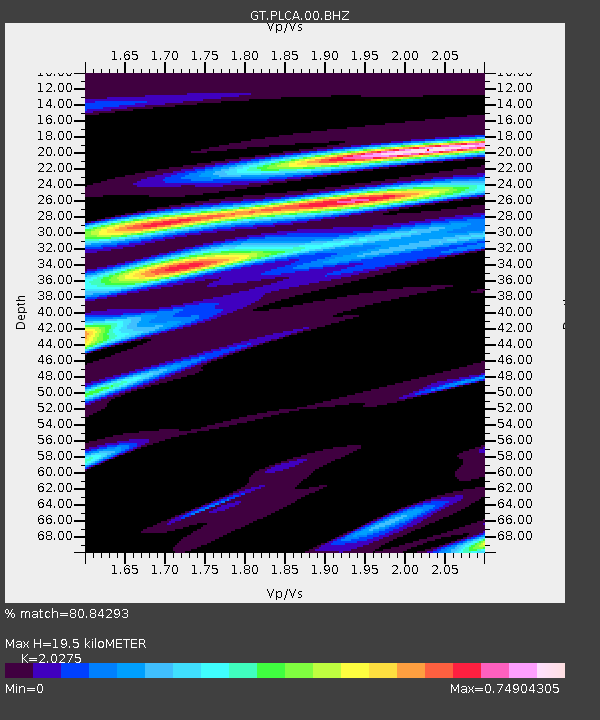
| Estimated Moho Depth: |
19.5 km |
| Estimated Crust Vp/Vs: |
2.03 |
| Assumed Crust Vp: |
6.597 km/s |
| Estimated Crust Vs: |
3.254 km/s |
| Estimated Crust Poisson's Ratio: |
0.34 |
|
| Radial Match: |
80.84293 % |
| Radial Bump: |
348 |
| Transverse Match: |
56.59304 % |
| Transverse Bump: |
400 |
| SOD ConfigId: |
26694651 |
| Insert Time: |
2021-12-30 21:18:42.105 +0000 |
| GWidth: |
2.5 |
| Max Bumps: |
400 |
| Tol: |
0.001 |
|

Signal To Noise
| Channel | StoN | STA | LTA |
| GT:PLCA:00:BHZ:20211216T21:21:03.975013Z | 3.1884258 | 1.0769862E-6 | 3.377799E-7 |
| GT:PLCA:00:BHN:20211216T21:21:03.975013Z | 2.237973 | 5.643863E-7 | 2.5218637E-7 |
| GT:PLCA:00:BHE:20211216T21:21:03.975013Z | 3.4602199 | 6.671813E-7 | 1.9281472E-7 |
| Arrivals |
| Ps | 3.3 SECOND |
| PpPs | 8.3 SECOND |
| PsPs/PpSs | 12 SECOND |


