You are here: Home > Network List > IW - Intermountain West Stations List
> Station MOOW Moose Ponds, Wyoming, USA > Earthquake Result Viewer
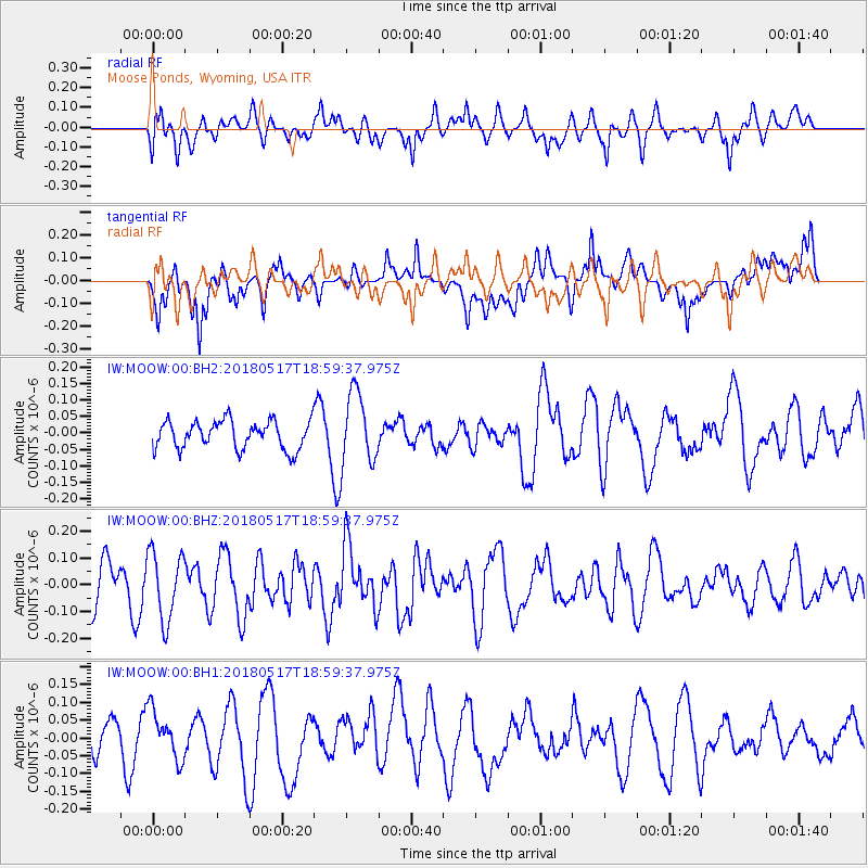
MOOW Moose Ponds, Wyoming, USA - Earthquake Result Viewer
*The percent match for this event was below the threshold and hence no stack was calculated.
| Earthquake location: |
South Of Mariana Islands |
| Earthquake latitude/longitude: |
13.0/145.3 |
| Earthquake time(UTC): |
2018/05/17 (137) 18:47:09 GMT |
| Earthquake Depth: |
37 km |
| Earthquake Magnitude: |
5.5 mb |
| Earthquake Catalog/Contributor: |
NEIC PDE/us |
|
| Network: |
IW Intermountain West |
| Station: |
MOOW Moose Ponds, Wyoming, USA |
| Lat/Lon: |
43.75 N/110.74 W |
| Elevation: |
2128 m |
|
| Distance: |
90.9 deg |
| Az: |
44.71 deg |
| Baz: |
288.873 deg |
| Ray Param: |
$rayparam |
*The percent match for this event was below the threshold and hence was not used in the summary stack. |
|
| Radial Match: |
49.189854 % |
| Radial Bump: |
400 |
| Transverse Match: |
52.69594 % |
| Transverse Bump: |
400 |
| SOD ConfigId: |
2665671 |
| Insert Time: |
2018-05-31 18:57:04.631 +0000 |
| GWidth: |
2.5 |
| Max Bumps: |
400 |
| Tol: |
0.001 |
|
Signal To Noise
| Channel | StoN | STA | LTA |
| IW:MOOW:00:BHZ:20180517T18:59:37.975Z | 1.4531354 | 1.2691685E-7 | 8.733999E-8 |
| IW:MOOW:00:BH1:20180517T18:59:37.975Z | 1.0583148 | 6.828173E-8 | 6.4519305E-8 |
| IW:MOOW:00:BH2:20180517T18:59:37.975Z | 2.5721002 | 1.09169406E-7 | 4.2443684E-8 |
| Arrivals |
| Ps | |
| PpPs | |
| PsPs/PpSs | |


