You are here: Home > Network List > AK - Alaska Regional Network Stations List
> Station MDM Murphy Dome > Earthquake Result Viewer
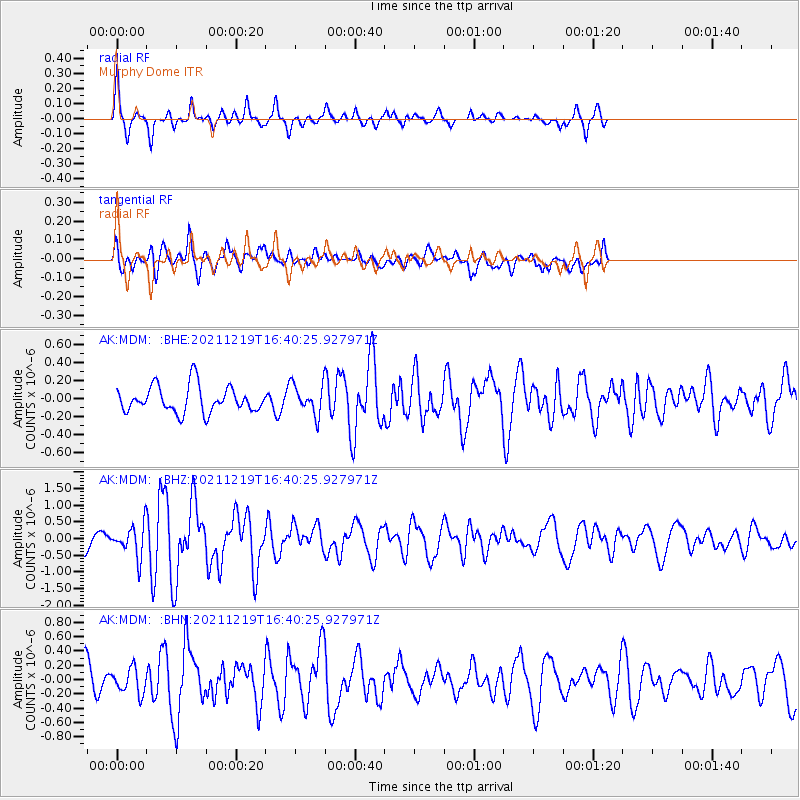
MDM Murphy Dome - Earthquake Result Viewer
*The percent match for this event was below the threshold and hence no stack was calculated.
| Earthquake location: |
Fiji Islands |
| Earthquake latitude/longitude: |
-16.3/178.6 |
| Earthquake time(UTC): |
2021/12/19 (353) 16:28:22 GMT |
| Earthquake Depth: |
10 km |
| Earthquake Magnitude: |
6.3 mww |
| Earthquake Catalog/Contributor: |
NEIC PDE/us |
|
| Network: |
AK Alaska Regional Network |
| Station: |
MDM Murphy Dome |
| Lat/Lon: |
64.96 N/148.23 W |
| Elevation: |
634 m |
|
| Distance: |
84.8 deg |
| Az: |
13.539 deg |
| Baz: |
211.89 deg |
| Ray Param: |
$rayparam |
*The percent match for this event was below the threshold and hence was not used in the summary stack. |
|
| Radial Match: |
69.04874 % |
| Radial Bump: |
286 |
| Transverse Match: |
71.63354 % |
| Transverse Bump: |
400 |
| SOD ConfigId: |
26694651 |
| Insert Time: |
2022-01-02 16:30:48.574 +0000 |
| GWidth: |
2.5 |
| Max Bumps: |
400 |
| Tol: |
0.001 |
|
Signal To Noise
| Channel | StoN | STA | LTA |
| AK:MDM: :BHZ:20211219T16:40:25.927971Z | 1.8327364 | 4.651807E-7 | 2.5381757E-7 |
| AK:MDM: :BHN:20211219T16:40:25.927971Z | 0.8316218 | 1.7550036E-7 | 2.1103386E-7 |
| AK:MDM: :BHE:20211219T16:40:25.927971Z | 1.1441829 | 1.6891319E-7 | 1.4762779E-7 |
| Arrivals |
| Ps | |
| PpPs | |
| PsPs/PpSs | |


