You are here: Home > Network List > AV - Alaska Volcano Observatory Stations List
> Station RDT Redoubt, Alaska > Earthquake Result Viewer
RDT Redoubt, Alaska - Earthquake Result Viewer
| Earthquake location: |
Fiji Islands |
| Earthquake latitude/longitude: |
-16.3/178.6 |
| Earthquake time(UTC): |
2021/12/19 (353) 16:28:22 GMT |
| Earthquake Depth: |
10 km |
| Earthquake Magnitude: |
6.3 mww |
| Earthquake Catalog/Contributor: |
NEIC PDE/us |
|
| Network: |
AV Alaska Volcano Observatory |
| Station: |
RDT Redoubt, Alaska |
| Lat/Lon: |
60.57 N/152.41 W |
| Elevation: |
930 m |
|
| Distance: |
80.1 deg |
| Az: |
14.085 deg |
| Baz: |
208.249 deg |
| Ray Param: |
0.04853333 |
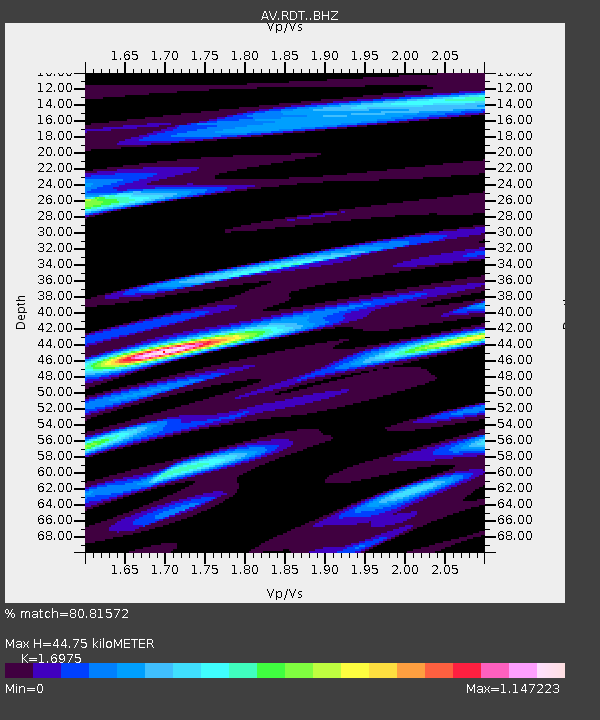
| Estimated Moho Depth: |
44.75 km |
| Estimated Crust Vp/Vs: |
1.70 |
| Assumed Crust Vp: |
6.566 km/s |
| Estimated Crust Vs: |
3.868 km/s |
| Estimated Crust Poisson's Ratio: |
0.23 |
|
| Radial Match: |
80.81572 % |
| Radial Bump: |
400 |
| Transverse Match: |
62.74006 % |
| Transverse Bump: |
400 |
| SOD ConfigId: |
26694651 |
| Insert Time: |
2022-01-02 16:33:41.793 +0000 |
| GWidth: |
2.5 |
| Max Bumps: |
400 |
| Tol: |
0.001 |
|

Signal To Noise
| Channel | StoN | STA | LTA |
| AV:RDT: :BHZ:20211219T16:40:01.119011Z | 1.9229665 | 3.338015E-7 | 1.7358676E-7 |
| AV:RDT: :BHN:20211219T16:40:01.119011Z | 0.532736 | 1.2567844E-7 | 2.3591127E-7 |
| AV:RDT: :BHE:20211219T16:40:01.119011Z | 0.6456167 | 9.9445806E-8 | 1.5403226E-7 |
| Arrivals |
| Ps | 4.9 SECOND |
| PpPs | 18 SECOND |
| PsPs/PpSs | 23 SECOND |


