You are here: Home > Network List > AZ - ANZA Regional Network Stations List
> Station SMER AZ.SMER > Earthquake Result Viewer
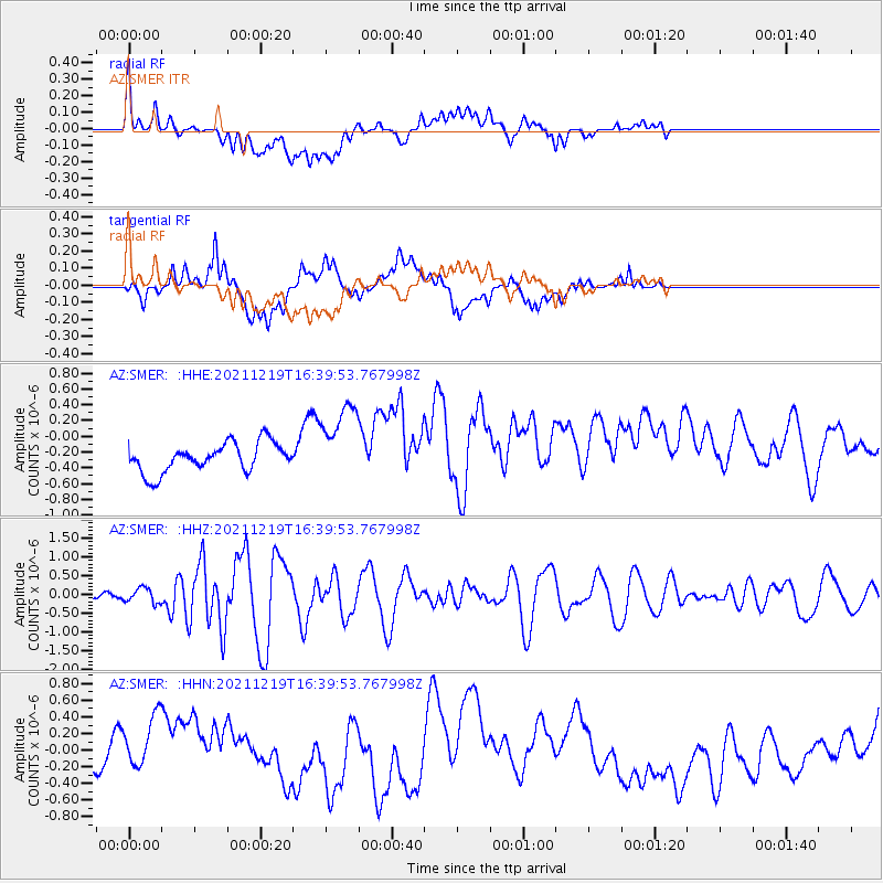
SMER AZ.SMER - Earthquake Result Viewer
*The percent match for this event was below the threshold and hence no stack was calculated.
| Earthquake location: |
Fiji Islands |
| Earthquake latitude/longitude: |
-16.3/178.6 |
| Earthquake time(UTC): |
2021/12/19 (353) 16:28:22 GMT |
| Earthquake Depth: |
10 km |
| Earthquake Magnitude: |
6.3 mww |
| Earthquake Catalog/Contributor: |
NEIC PDE/us |
|
| Network: |
AZ ANZA Regional Network |
| Station: |
SMER AZ.SMER |
| Lat/Lon: |
33.46 N/117.17 W |
| Elevation: |
355 m |
|
| Distance: |
78.7 deg |
| Az: |
50.173 deg |
| Baz: |
241.919 deg |
| Ray Param: |
$rayparam |
*The percent match for this event was below the threshold and hence was not used in the summary stack. |
|
| Radial Match: |
47.689743 % |
| Radial Bump: |
400 |
| Transverse Match: |
48.116745 % |
| Transverse Bump: |
400 |
| SOD ConfigId: |
26694651 |
| Insert Time: |
2022-01-02 16:34:14.273 +0000 |
| GWidth: |
2.5 |
| Max Bumps: |
400 |
| Tol: |
0.001 |
|
Signal To Noise
| Channel | StoN | STA | LTA |
| AZ:SMER: :HHZ:20211219T16:39:53.767998Z | 1.300175 | 1.9371144E-7 | 1.4898875E-7 |
| AZ:SMER: :HHN:20211219T16:39:53.767998Z | 2.0934234 | 4.2024075E-7 | 2.0074333E-7 |
| AZ:SMER: :HHE:20211219T16:39:53.767998Z | 2.730188 | 5.0164124E-7 | 1.8373873E-7 |
| Arrivals |
| Ps | |
| PpPs | |
| PsPs/PpSs | |


