You are here: Home > Network List > CI - Caltech Regional Seismic Network Stations List
> Station DAN Danby, California, USA > Earthquake Result Viewer
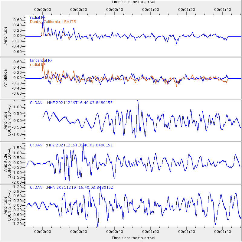
DAN Danby, California, USA - Earthquake Result Viewer
*The percent match for this event was below the threshold and hence no stack was calculated.
| Earthquake location: |
Fiji Islands |
| Earthquake latitude/longitude: |
-16.3/178.6 |
| Earthquake time(UTC): |
2021/12/19 (353) 16:28:22 GMT |
| Earthquake Depth: |
10 km |
| Earthquake Magnitude: |
6.3 mww |
| Earthquake Catalog/Contributor: |
NEIC PDE/us |
|
| Network: |
CI Caltech Regional Seismic Network |
| Station: |
DAN Danby, California, USA |
| Lat/Lon: |
34.64 N/115.38 W |
| Elevation: |
398 m |
|
| Distance: |
80.6 deg |
| Az: |
49.814 deg |
| Baz: |
242.852 deg |
| Ray Param: |
$rayparam |
*The percent match for this event was below the threshold and hence was not used in the summary stack. |
|
| Radial Match: |
64.45578 % |
| Radial Bump: |
400 |
| Transverse Match: |
68.498146 % |
| Transverse Bump: |
400 |
| SOD ConfigId: |
26694651 |
| Insert Time: |
2022-01-02 16:36:02.677 +0000 |
| GWidth: |
2.5 |
| Max Bumps: |
400 |
| Tol: |
0.001 |
|
Signal To Noise
| Channel | StoN | STA | LTA |
| CI:DAN: :HHZ:20211219T16:40:03.848015Z | 0.7734224 | 1.2328142E-7 | 1.5939727E-7 |
| CI:DAN: :HHN:20211219T16:40:03.848015Z | 0.70858234 | 1.8803487E-7 | 2.6536773E-7 |
| CI:DAN: :HHE:20211219T16:40:03.848015Z | 1.6703752 | 4.800687E-7 | 2.874017E-7 |
| Arrivals |
| Ps | |
| PpPs | |
| PsPs/PpSs | |


