You are here: Home > Network List > IW - Intermountain West Stations List
> Station MOOW Moose Ponds, Wyoming, USA > Earthquake Result Viewer
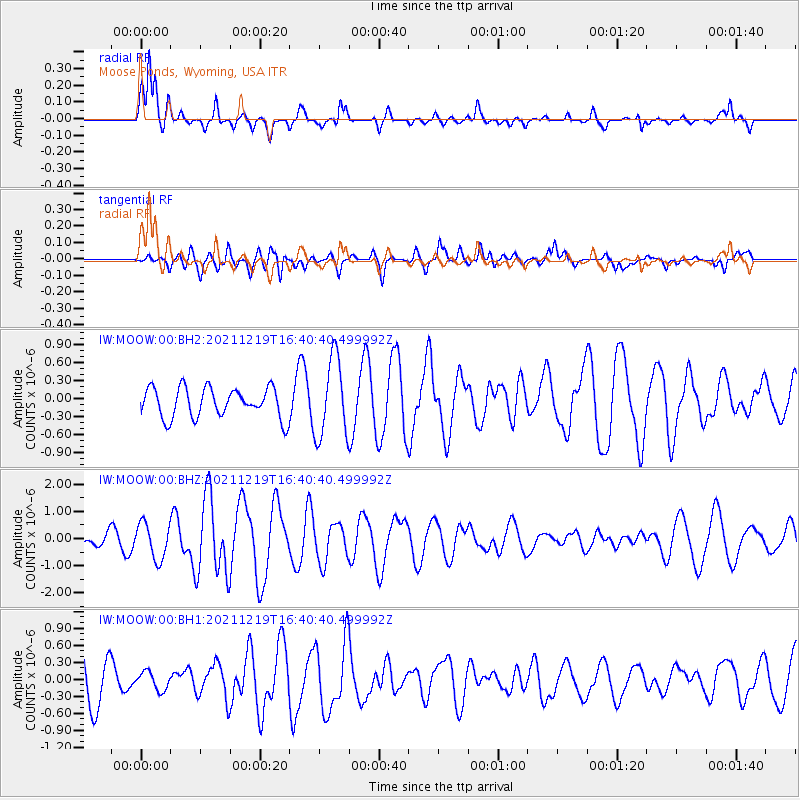
MOOW Moose Ponds, Wyoming, USA - Earthquake Result Viewer
*The percent match for this event was below the threshold and hence no stack was calculated.
| Earthquake location: |
Fiji Islands |
| Earthquake latitude/longitude: |
-16.3/178.6 |
| Earthquake time(UTC): |
2021/12/19 (353) 16:28:22 GMT |
| Earthquake Depth: |
10 km |
| Earthquake Magnitude: |
6.3 mww |
| Earthquake Catalog/Contributor: |
NEIC PDE/us |
|
| Network: |
IW Intermountain West |
| Station: |
MOOW Moose Ponds, Wyoming, USA |
| Lat/Lon: |
43.75 N/110.74 W |
| Elevation: |
2128 m |
|
| Distance: |
87.8 deg |
| Az: |
43.195 deg |
| Baz: |
245.109 deg |
| Ray Param: |
$rayparam |
*The percent match for this event was below the threshold and hence was not used in the summary stack. |
|
| Radial Match: |
79.80869 % |
| Radial Bump: |
346 |
| Transverse Match: |
46.267136 % |
| Transverse Bump: |
400 |
| SOD ConfigId: |
26694651 |
| Insert Time: |
2022-01-02 16:39:33.011 +0000 |
| GWidth: |
2.5 |
| Max Bumps: |
400 |
| Tol: |
0.001 |
|
Signal To Noise
| Channel | StoN | STA | LTA |
| IW:MOOW:00:BHZ:20211219T16:40:40.499992Z | 2.0698051 | 6.608671E-7 | 3.192895E-7 |
| IW:MOOW:00:BH1:20211219T16:40:40.499992Z | 0.48270264 | 1.6131155E-7 | 3.3418408E-7 |
| IW:MOOW:00:BH2:20211219T16:40:40.499992Z | 2.654356 | 6.623527E-7 | 2.4953425E-7 |
| Arrivals |
| Ps | |
| PpPs | |
| PsPs/PpSs | |


