You are here: Home > Network List > GT - Global Telemetered Seismograph Network (USAF/USGS) Stations List
> Station BOSA Boshof, South Africa > Earthquake Result Viewer
BOSA Boshof, South Africa - Earthquake Result Viewer
| Earthquake location: |
South Sandwich Islands Region |
| Earthquake latitude/longitude: |
-56.9/-24.1 |
| Earthquake time(UTC): |
2021/12/20 (354) 03:39:34 GMT |
| Earthquake Depth: |
10 km |
| Earthquake Magnitude: |
6.0 mww |
| Earthquake Catalog/Contributor: |
NEIC PDE/us |
|
| Network: |
GT Global Telemetered Seismograph Network (USAF/USGS) |
| Station: |
BOSA Boshof, South Africa |
| Lat/Lon: |
28.61 S/25.26 E |
| Elevation: |
1280 m |
|
| Distance: |
44.5 deg |
| Az: |
71.989 deg |
| Baz: |
216.457 deg |
| Ray Param: |
0.071867906 |
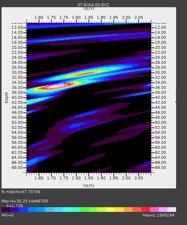
| Estimated Moho Depth: |
35.25 km |
| Estimated Crust Vp/Vs: |
1.73 |
| Assumed Crust Vp: |
6.459 km/s |
| Estimated Crust Vs: |
3.745 km/s |
| Estimated Crust Poisson's Ratio: |
0.25 |
|
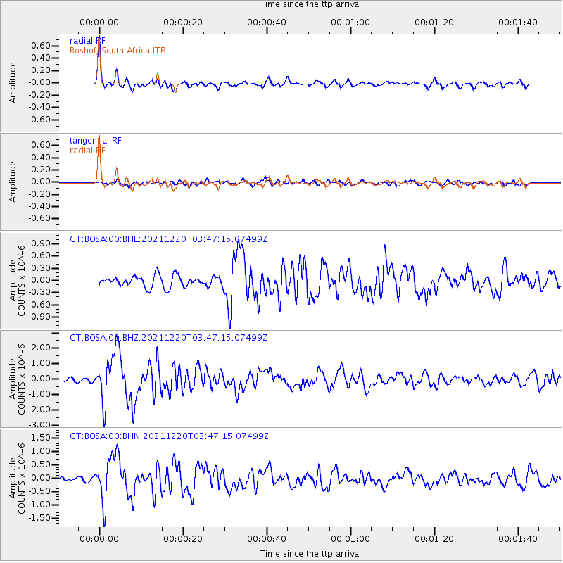
| Radial Match: |
87.78786 % |
| Radial Bump: |
318 |
| Transverse Match: |
74.96117 % |
| Transverse Bump: |
400 |
| SOD ConfigId: |
26694651 |
| Insert Time: |
2022-01-03 03:43:19.383 +0000 |
| GWidth: |
2.5 |
| Max Bumps: |
400 |
| Tol: |
0.001 |
|
Signal To Noise
| Channel | StoN | STA | LTA |
| GT:BOSA:00:BHZ:20211220T03:47:15.07499Z | 9.33532 | 1.6543257E-6 | 1.7721146E-7 |
| GT:BOSA:00:BHN:20211220T03:47:15.07499Z | 7.060721 | 8.863471E-7 | 1.255321E-7 |
| GT:BOSA:00:BHE:20211220T03:47:15.07499Z | 4.8919535 | 6.7765785E-7 | 1.38525E-7 |
| Arrivals |
| Ps | 4.2 SECOND |
| PpPs | 14 SECOND |
| PsPs/PpSs | 18 SECOND |


