You are here: Home > Network List > AK - Alaska Regional Network Stations List
> Station F21K Alatna River, AK, USA > Earthquake Result Viewer
F21K Alatna River, AK, USA - Earthquake Result Viewer
| Earthquake location: |
Near Coast Of Northern Calif. |
| Earthquake latitude/longitude: |
40.3/-124.7 |
| Earthquake time(UTC): |
2021/12/20 (354) 20:10:18 GMT |
| Earthquake Depth: |
9.3 km |
| Earthquake Magnitude: |
6.2 Mw |
| Earthquake Catalog/Contributor: |
NEIC PDE/nc |
|
| Network: |
AK Alaska Regional Network |
| Station: |
F21K Alatna River, AK, USA |
| Lat/Lon: |
67.22 N/153.48 W |
| Elevation: |
597 m |
|
| Distance: |
31.3 deg |
| Az: |
338.861 deg |
| Baz: |
134.911 deg |
| Ray Param: |
0.079136424 |
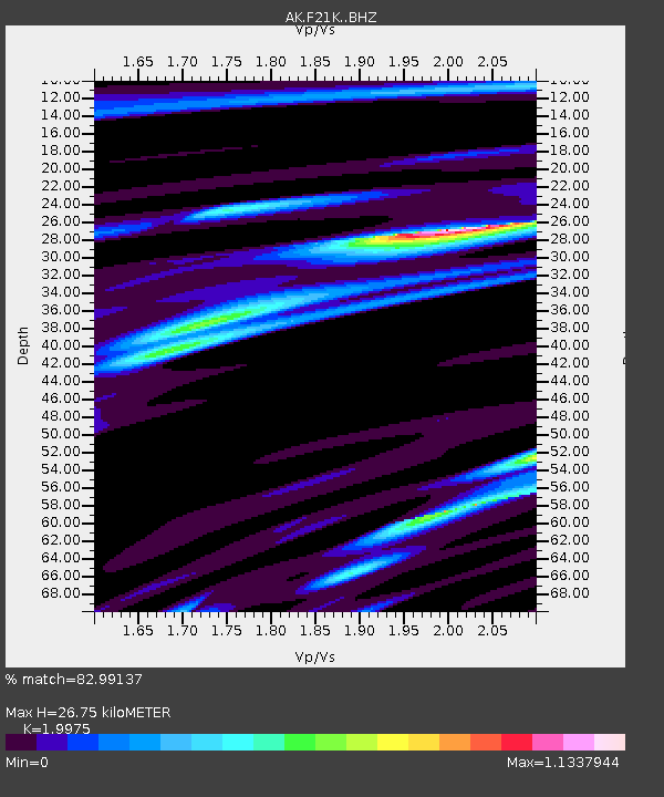
| Estimated Moho Depth: |
26.75 km |
| Estimated Crust Vp/Vs: |
2.00 |
| Assumed Crust Vp: |
6.455 km/s |
| Estimated Crust Vs: |
3.232 km/s |
| Estimated Crust Poisson's Ratio: |
0.33 |
|
| Radial Match: |
82.99137 % |
| Radial Bump: |
300 |
| Transverse Match: |
57.98508 % |
| Transverse Bump: |
400 |
| SOD ConfigId: |
26694651 |
| Insert Time: |
2022-01-03 20:11:19.089 +0000 |
| GWidth: |
2.5 |
| Max Bumps: |
400 |
| Tol: |
0.001 |
|

Signal To Noise
| Channel | StoN | STA | LTA |
| AK:F21K: :BHZ:20211220T20:16:07.860013Z | 1.8688691 | 2.8610296E-7 | 1.5308882E-7 |
| AK:F21K: :BHN:20211220T20:16:07.860013Z | 0.67196244 | 8.632052E-8 | 1.2846033E-7 |
| AK:F21K: :BHE:20211220T20:16:07.860013Z | 1.8358637 | 1.7623213E-7 | 9.599413E-8 |
| Arrivals |
| Ps | 4.4 SECOND |
| PpPs | 12 SECOND |
| PsPs/PpSs | 16 SECOND |


