You are here: Home > Network List > BK - Berkeley Digital Seismograph Network Stations List
> Station HUMO Hull Mountain, OR > Earthquake Result Viewer
HUMO Hull Mountain, OR - Earthquake Result Viewer
*The percent match for this event was below the threshold and hence no stack was calculated.
| Earthquake location: |
South Of Kermadec Islands |
| Earthquake latitude/longitude: |
-34.6/-178.4 |
| Earthquake time(UTC): |
2018/05/18 (138) 01:45:31 GMT |
| Earthquake Depth: |
11 km |
| Earthquake Magnitude: |
6.2 Mww |
| Earthquake Catalog/Contributor: |
NEIC PDE/us |
|
| Network: |
BK Berkeley Digital Seismograph Network |
| Station: |
HUMO Hull Mountain, OR |
| Lat/Lon: |
42.61 N/122.96 W |
| Elevation: |
555 m |
|
| Distance: |
92.0 deg |
| Az: |
37.482 deg |
| Baz: |
222.869 deg |
| Ray Param: |
$rayparam |
*The percent match for this event was below the threshold and hence was not used in the summary stack. |
|
| Radial Match: |
75.83131 % |
| Radial Bump: |
400 |
| Transverse Match: |
63.301914 % |
| Transverse Bump: |
400 |
| SOD ConfigId: |
2665671 |
| Insert Time: |
2018-06-01 01:46:47.894 +0000 |
| GWidth: |
2.5 |
| Max Bumps: |
400 |
| Tol: |
0.001 |
|
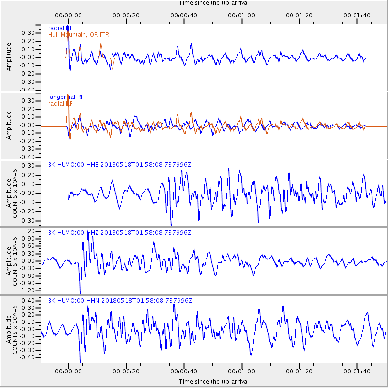
Signal To Noise
| Channel | StoN | STA | LTA |
| BK:HUMO:00:HHZ:20180518T01:58:08.737996Z | 5.0348334 | 4.260262E-7 | 8.461574E-8 |
| BK:HUMO:00:HHN:20180518T01:58:08.737996Z | 3.0182915 | 1.4960796E-7 | 4.9567102E-8 |
| BK:HUMO:00:HHE:20180518T01:58:08.737996Z | 1.8316061 | 1.0151581E-7 | 5.5424476E-8 |
| Arrivals |
| Ps | |
| PpPs | |
| PsPs/PpSs | |


