You are here: Home > Network List > IU - Global Seismograph Network (GSN - IRIS/USGS) Stations List
> Station MAKZ Makanchi, Kazakhstan > Earthquake Result Viewer
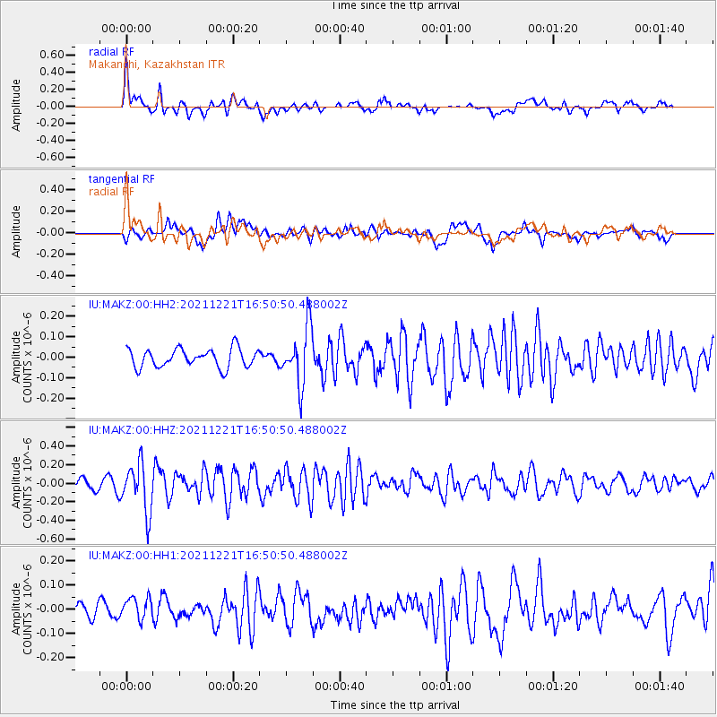
MAKZ Makanchi, Kazakhstan - Earthquake Result Viewer
*The percent match for this event was below the threshold and hence no stack was calculated.
| Earthquake location: |
Southeast Of Honshu, Japan |
| Earthquake latitude/longitude: |
31.2/142.3 |
| Earthquake time(UTC): |
2021/12/21 (355) 16:42:40 GMT |
| Earthquake Depth: |
10 km |
| Earthquake Magnitude: |
4.9 Mww |
| Earthquake Catalog/Contributor: |
NEIC PDE/us |
|
| Network: |
IU Global Seismograph Network (GSN - IRIS/USGS) |
| Station: |
MAKZ Makanchi, Kazakhstan |
| Lat/Lon: |
46.81 N/81.98 E |
| Elevation: |
600 m |
|
| Distance: |
48.2 deg |
| Az: |
306.848 deg |
| Baz: |
86.475 deg |
| Ray Param: |
$rayparam |
*The percent match for this event was below the threshold and hence was not used in the summary stack. |
|
| Radial Match: |
77.317345 % |
| Radial Bump: |
400 |
| Transverse Match: |
65.27053 % |
| Transverse Bump: |
400 |
| SOD ConfigId: |
26694651 |
| Insert Time: |
2022-01-04 16:55:08.142 +0000 |
| GWidth: |
2.5 |
| Max Bumps: |
400 |
| Tol: |
0.001 |
|
Signal To Noise
| Channel | StoN | STA | LTA |
| IU:MAKZ:00:HHZ:20211221T16:50:50.488002Z | 5.138608 | 2.63841E-7 | 5.134484E-8 |
| IU:MAKZ:00:HH1:20211221T16:50:50.488002Z | 2.275147 | 5.0852616E-8 | 2.2351355E-8 |
| IU:MAKZ:00:HH2:20211221T16:50:50.488002Z | 3.1664255 | 1.4225658E-7 | 4.4926555E-8 |
| Arrivals |
| Ps | |
| PpPs | |
| PsPs/PpSs | |


