You are here: Home > Network List > NN - Western Great Basin/Eastern Sierra Nevada Stations List
> Station QSM Queen of Sheba Mine, CA. (GPS 01/17/2001) w84gm > Earthquake Result Viewer
QSM Queen of Sheba Mine, CA. (GPS 01/17/2001) w84gm - Earthquake Result Viewer
| Earthquake location: |
Southern Alaska |
| Earthquake latitude/longitude: |
60.2/-153.3 |
| Earthquake time(UTC): |
2021/12/21 (355) 22:42:14 GMT |
| Earthquake Depth: |
134 km |
| Earthquake Magnitude: |
5.9 ml |
| Earthquake Catalog/Contributor: |
NEIC PDE/ak |
|
| Network: |
NN Western Great Basin/Eastern Sierra Nevada |
| Station: |
QSM Queen of Sheba Mine, CA. (GPS 01/17/2001) w84gm |
| Lat/Lon: |
35.97 N/116.87 W |
| Elevation: |
385 m |
|
| Distance: |
33.6 deg |
| Az: |
119.536 deg |
| Baz: |
327.561 deg |
| Ray Param: |
0.07772977 |
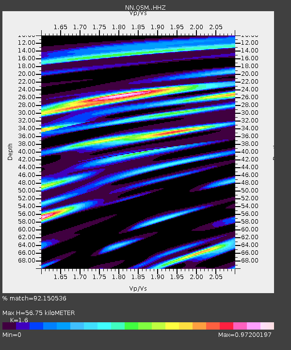
| Estimated Moho Depth: |
56.75 km |
| Estimated Crust Vp/Vs: |
1.60 |
| Assumed Crust Vp: |
6.276 km/s |
| Estimated Crust Vs: |
3.922 km/s |
| Estimated Crust Poisson's Ratio: |
0.18 |
|
| Radial Match: |
92.150536 % |
| Radial Bump: |
364 |
| Transverse Match: |
63.395515 % |
| Transverse Bump: |
400 |
| SOD ConfigId: |
26694651 |
| Insert Time: |
2022-01-04 22:59:30.058 +0000 |
| GWidth: |
2.5 |
| Max Bumps: |
400 |
| Tol: |
0.001 |
|

Signal To Noise
| Channel | StoN | STA | LTA |
| NN:QSM: :HHZ:20211221T22:48:11.787993Z | 2.2768507 | 3.585608E-7 | 1.5748105E-7 |
| NN:QSM: :HHN:20211221T22:48:11.787993Z | 1.1502041 | 2.7109647E-7 | 2.3569424E-7 |
| NN:QSM: :HHE:20211221T22:48:11.787993Z | 0.9096559 | 1.4972126E-7 | 1.6459109E-7 |
| Arrivals |
| Ps | 5.9 SECOND |
| PpPs | 22 SECOND |
| PsPs/PpSs | 28 SECOND |


