You are here: Home > Network List > TX - Texas Seismological Network Stations List
> Station SAND Sanderson > Earthquake Result Viewer
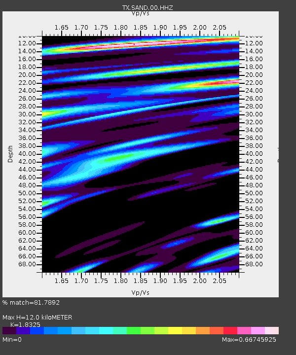
SAND Sanderson - Earthquake Result Viewer
| Earthquake location: |
Southern Alaska |
| Earthquake latitude/longitude: |
60.2/-153.3 |
| Earthquake time(UTC): |
2021/12/21 (355) 22:42:14 GMT |
| Earthquake Depth: |
134 km |
| Earthquake Magnitude: |
5.9 ml |
| Earthquake Catalog/Contributor: |
NEIC PDE/ak |
|
| Network: |
TX Texas Seismological Network |
| Station: |
SAND Sanderson |
| Lat/Lon: |
29.95 N/102.12 W |
| Elevation: |
689 m |
|
| Distance: |
45.4 deg |
| Az: |
108.243 deg |
| Baz: |
326.816 deg |
| Ray Param: |
0.07085494 |
| Estimated Moho Depth: |
12.0 km |
| Estimated Crust Vp/Vs: |
1.83 |
| Assumed Crust Vp: |
6.419 km/s |
| Estimated Crust Vs: |
3.503 km/s |
| Estimated Crust Poisson's Ratio: |
0.29 |
|
| Radial Match: |
81.7892 % |
| Radial Bump: |
360 |
| Transverse Match: |
83.62901 % |
| Transverse Bump: |
400 |
| SOD ConfigId: |
26694651 |
| Insert Time: |
2022-01-04 23:05:08.207 +0000 |
| GWidth: |
2.5 |
| Max Bumps: |
400 |
| Tol: |
0.001 |
|

Signal To Noise
| Channel | StoN | STA | LTA |
| TX:SAND:00:HHZ:20211221T22:49:49.045012Z | 2.3892627 | 3.5792394E-7 | 1.4980517E-7 |
| TX:SAND:00:HH1:20211221T22:49:49.045012Z | 0.86666465 | 1.0068579E-7 | 1.1617618E-7 |
| TX:SAND:00:HH2:20211221T22:49:49.045012Z | 2.018144 | 2.4594428E-7 | 1.2186656E-7 |
| Arrivals |
| Ps | 1.7 SECOND |
| PpPs | 5.0 SECOND |
| PsPs/PpSs | 6.6 SECOND |


