You are here: Home > Network List > US - United States National Seismic Network Stations List
> Station AGMN Agassiz National Wildlife Refuge, Minnesota, USA > Earthquake Result Viewer
AGMN Agassiz National Wildlife Refuge, Minnesota, USA - Earthquake Result Viewer
*The percent match for this event was below the threshold and hence no stack was calculated.
| Earthquake location: |
Southern Alaska |
| Earthquake latitude/longitude: |
60.2/-153.3 |
| Earthquake time(UTC): |
2021/12/21 (355) 22:42:14 GMT |
| Earthquake Depth: |
134 km |
| Earthquake Magnitude: |
5.9 ml |
| Earthquake Catalog/Contributor: |
NEIC PDE/ak |
|
| Network: |
US United States National Seismic Network |
| Station: |
AGMN Agassiz National Wildlife Refuge, Minnesota, USA |
| Lat/Lon: |
48.30 N/95.86 W |
| Elevation: |
351 m |
|
| Distance: |
34.5 deg |
| Az: |
83.816 deg |
| Baz: |
311.872 deg |
| Ray Param: |
$rayparam |
*The percent match for this event was below the threshold and hence was not used in the summary stack. |
|
| Radial Match: |
47.321575 % |
| Radial Bump: |
400 |
| Transverse Match: |
63.26914 % |
| Transverse Bump: |
400 |
| SOD ConfigId: |
26694651 |
| Insert Time: |
2022-01-04 23:05:22.415 +0000 |
| GWidth: |
2.5 |
| Max Bumps: |
400 |
| Tol: |
0.001 |
|
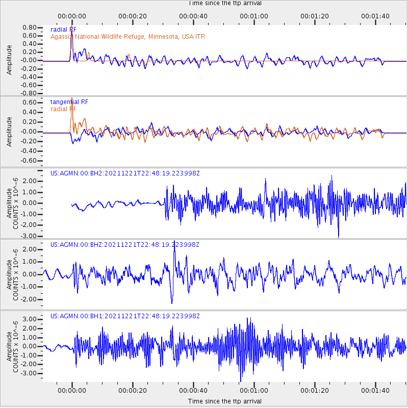
Signal To Noise
| Channel | StoN | STA | LTA |
| US:AGMN:00:BHZ:20211221T22:48:19.223998Z | 2.098535 | 5.458418E-7 | 2.601061E-7 |
| US:AGMN:00:BH1:20211221T22:48:19.223998Z | 2.6395802 | 7.1984954E-7 | 2.7271363E-7 |
| US:AGMN:00:BH2:20211221T22:48:19.223998Z | 3.1924226 | 7.007571E-7 | 2.1950636E-7 |
| Arrivals |
| Ps | |
| PpPs | |
| PsPs/PpSs | |


