You are here: Home > Network List > US - United States National Seismic Network Stations List
> Station DGMT Dagmar, Montana, USA > Earthquake Result Viewer
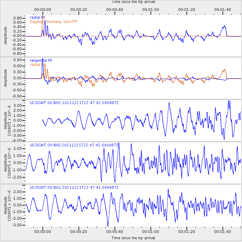
DGMT Dagmar, Montana, USA - Earthquake Result Viewer
*The percent match for this event was below the threshold and hence no stack was calculated.
| Earthquake location: |
Southern Alaska |
| Earthquake latitude/longitude: |
60.2/-153.3 |
| Earthquake time(UTC): |
2021/12/21 (355) 22:42:14 GMT |
| Earthquake Depth: |
134 km |
| Earthquake Magnitude: |
5.9 ml |
| Earthquake Catalog/Contributor: |
NEIC PDE/ak |
|
| Network: |
US United States National Seismic Network |
| Station: |
DGMT Dagmar, Montana, USA |
| Lat/Lon: |
48.47 N/104.20 W |
| Elevation: |
0.0 m |
|
| Distance: |
30.2 deg |
| Az: |
90.466 deg |
| Baz: |
311.28 deg |
| Ray Param: |
$rayparam |
*The percent match for this event was below the threshold and hence was not used in the summary stack. |
|
| Radial Match: |
58.651443 % |
| Radial Bump: |
400 |
| Transverse Match: |
87.97243 % |
| Transverse Bump: |
308 |
| SOD ConfigId: |
26694651 |
| Insert Time: |
2022-01-04 23:05:29.893 +0000 |
| GWidth: |
2.5 |
| Max Bumps: |
400 |
| Tol: |
0.001 |
|
Signal To Noise
| Channel | StoN | STA | LTA |
| US:DGMT:00:BHZ:20211221T22:47:42.049987Z | 1.6717355 | 9.530005E-7 | 5.7006656E-7 |
| US:DGMT:00:BH1:20211221T22:47:42.049987Z | 2.61851 | 1.2657432E-6 | 4.83383E-7 |
| US:DGMT:00:BH2:20211221T22:47:42.049987Z | 0.6449605 | 4.7606483E-7 | 7.381302E-7 |
| Arrivals |
| Ps | |
| PpPs | |
| PsPs/PpSs | |


