You are here: Home > Network List > GS - US Geological Survey Networks Stations List
> Station DEC08 Union Local 159 Surface Site > Earthquake Result Viewer
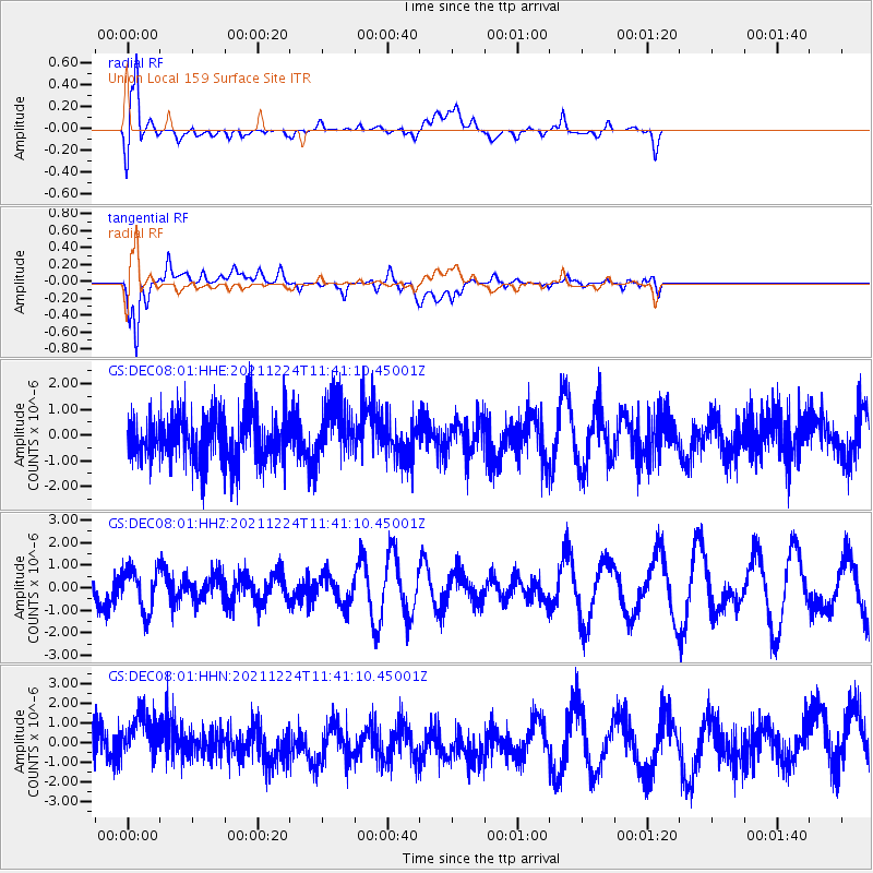
DEC08 Union Local 159 Surface Site - Earthquake Result Viewer
*The percent match for this event was below the threshold and hence no stack was calculated.
| Earthquake location: |
Hawaii |
| Earthquake latitude/longitude: |
18.9/-155.2 |
| Earthquake time(UTC): |
2021/12/24 (358) 11:31:34 GMT |
| Earthquake Depth: |
11 km |
| Earthquake Magnitude: |
4.9 Ml |
| Earthquake Catalog/Contributor: |
NEIC PDE/hv |
|
| Network: |
GS US Geological Survey Networks |
| Station: |
DEC08 Union Local 159 Surface Site |
| Lat/Lon: |
39.86 N/88.92 W |
| Elevation: |
210 m |
|
| Distance: |
60.1 deg |
| Az: |
54.373 deg |
| Baz: |
270.287 deg |
| Ray Param: |
$rayparam |
*The percent match for this event was below the threshold and hence was not used in the summary stack. |
|
| Radial Match: |
74.6525 % |
| Radial Bump: |
400 |
| Transverse Match: |
77.66062 % |
| Transverse Bump: |
400 |
| SOD ConfigId: |
26694651 |
| Insert Time: |
2022-01-07 11:42:29.452 +0000 |
| GWidth: |
2.5 |
| Max Bumps: |
400 |
| Tol: |
0.001 |
|
Signal To Noise
| Channel | StoN | STA | LTA |
| GS:DEC08:01:HHZ:20211224T11:41:10.45001Z | 1.1614524 | 9.442169E-7 | 8.129622E-7 |
| GS:DEC08:01:HHN:20211224T11:41:10.45001Z | 1.461667 | 1.2830775E-6 | 8.778179E-7 |
| GS:DEC08:01:HHE:20211224T11:41:10.45001Z | 1.1839675 | 1.1511645E-6 | 9.722941E-7 |
| Arrivals |
| Ps | |
| PpPs | |
| PsPs/PpSs | |


