You are here: Home > Network List > AV - Alaska Volcano Observatory Stations List
> Station GAEA East, Gareloi Volcano, Alaska > Earthquake Result Viewer
GAEA East, Gareloi Volcano, Alaska - Earthquake Result Viewer
| Earthquake location: |
Myanmar-China Border Region |
| Earthquake latitude/longitude: |
22.4/101.7 |
| Earthquake time(UTC): |
2021/12/24 (358) 13:43:22 GMT |
| Earthquake Depth: |
10 km |
| Earthquake Magnitude: |
5.7 mww |
| Earthquake Catalog/Contributor: |
NEIC PDE/us |
|
| Network: |
AV Alaska Volcano Observatory |
| Station: |
GAEA East, Gareloi Volcano, Alaska |
| Lat/Lon: |
51.78 N/178.75 W |
| Elevation: |
326 m |
|
| Distance: |
66.4 deg |
| Az: |
41.82 deg |
| Baz: |
276.493 deg |
| Ray Param: |
0.05765467 |
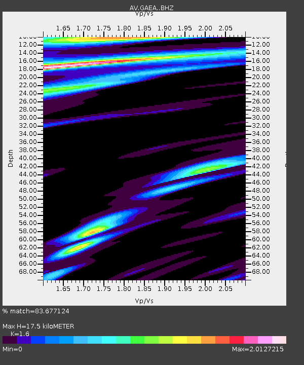
| Estimated Moho Depth: |
17.5 km |
| Estimated Crust Vp/Vs: |
1.60 |
| Assumed Crust Vp: |
6.048 km/s |
| Estimated Crust Vs: |
3.78 km/s |
| Estimated Crust Poisson's Ratio: |
0.18 |
|
| Radial Match: |
83.677124 % |
| Radial Bump: |
400 |
| Transverse Match: |
53.415752 % |
| Transverse Bump: |
400 |
| SOD ConfigId: |
26694651 |
| Insert Time: |
2022-01-07 13:48:26.400 +0000 |
| GWidth: |
2.5 |
| Max Bumps: |
400 |
| Tol: |
0.001 |
|

Signal To Noise
| Channel | StoN | STA | LTA |
| AV:GAEA: :BHZ:20211224T13:53:40.798979Z | 0.48229843 | 1.5692588E-6 | 3.2537089E-6 |
| AV:GAEA: :BHN:20211224T13:53:40.798979Z | 1.0629946 | 2.4488759E-6 | 2.303752E-6 |
| AV:GAEA: :BHE:20211224T13:53:40.798979Z | 0.5634822 | 3.0717606E-6 | 5.451389E-6 |
| Arrivals |
| Ps | 1.8 SECOND |
| PpPs | 7.2 SECOND |
| PsPs/PpSs | 9.0 SECOND |


