You are here: Home > Network List > IU - Global Seismograph Network (GSN - IRIS/USGS) Stations List
> Station KIP Kipapa, Hawaii, USA > Earthquake Result Viewer
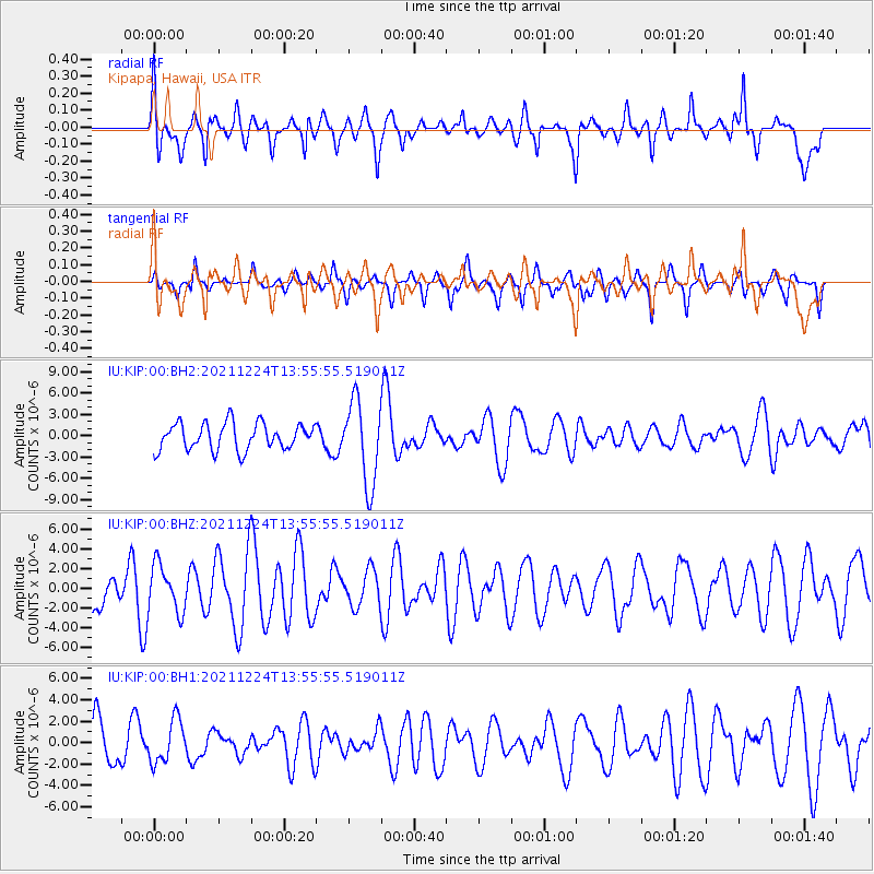
KIP Kipapa, Hawaii, USA - Earthquake Result Viewer
*The percent match for this event was below the threshold and hence no stack was calculated.
| Earthquake location: |
Myanmar-China Border Region |
| Earthquake latitude/longitude: |
22.4/101.7 |
| Earthquake time(UTC): |
2021/12/24 (358) 13:43:22 GMT |
| Earthquake Depth: |
10 km |
| Earthquake Magnitude: |
5.7 mww |
| Earthquake Catalog/Contributor: |
NEIC PDE/us |
|
| Network: |
IU Global Seismograph Network (GSN - IRIS/USGS) |
| Station: |
KIP Kipapa, Hawaii, USA |
| Lat/Lon: |
21.42 N/158.01 W |
| Elevation: |
70 m |
|
| Distance: |
91.0 deg |
| Az: |
66.471 deg |
| Baz: |
294.37 deg |
| Ray Param: |
$rayparam |
*The percent match for this event was below the threshold and hence was not used in the summary stack. |
|
| Radial Match: |
54.28227 % |
| Radial Bump: |
400 |
| Transverse Match: |
51.532223 % |
| Transverse Bump: |
400 |
| SOD ConfigId: |
26694651 |
| Insert Time: |
2022-01-07 13:52:50.204 +0000 |
| GWidth: |
2.5 |
| Max Bumps: |
400 |
| Tol: |
0.001 |
|
Signal To Noise
| Channel | StoN | STA | LTA |
| IU:KIP:00:BHZ:20211224T13:55:55.519011Z | 1.1605408 | 2.3651482E-6 | 2.0379705E-6 |
| IU:KIP:00:BH1:20211224T13:55:55.519011Z | 0.6908565 | 1.9906279E-6 | 2.881391E-6 |
| IU:KIP:00:BH2:20211224T13:55:55.519011Z | 3.1098337 | 5.8107166E-6 | 1.8684976E-6 |
| Arrivals |
| Ps | |
| PpPs | |
| PsPs/PpSs | |


